You are here: Home > Network List > TA - USArray Transportable Network (new EarthScope stations) Stations List
> Station R32K Eaglecrest, AK, USA > Earthquake Result Viewer
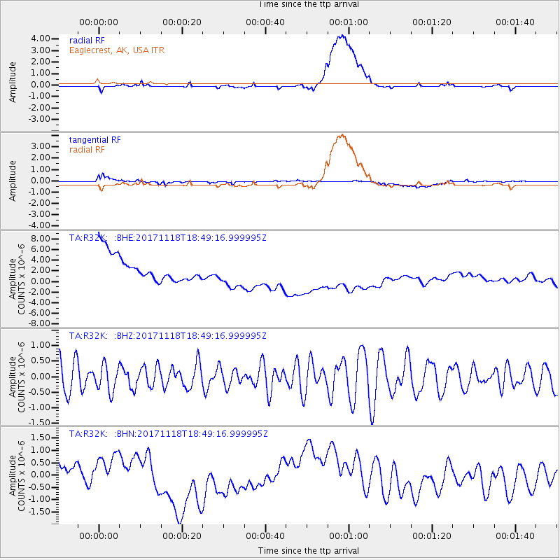
R32K Eaglecrest, AK, USA - Earthquake Result Viewer
*The percent match for this event was below the threshold and hence no stack was calculated.
| Earthquake location: |
Halmahera, Indonesia |
| Earthquake latitude/longitude: |
2.4/128.1 |
| Earthquake time(UTC): |
2017/11/18 (322) 18:36:41 GMT |
| Earthquake Depth: |
17 km |
| Earthquake Magnitude: |
5.4 Mww |
| Earthquake Catalog/Contributor: |
NEIC PDE/us |
|
| Network: |
TA USArray Transportable Network (new EarthScope stations) |
| Station: |
R32K Eaglecrest, AK, USA |
| Lat/Lon: |
58.27 N/134.52 W |
| Elevation: |
386 m |
|
| Distance: |
91.9 deg |
| Az: |
31.624 deg |
| Baz: |
277.487 deg |
| Ray Param: |
$rayparam |
*The percent match for this event was below the threshold and hence was not used in the summary stack. |
|
| Radial Match: |
24.359188 % |
| Radial Bump: |
400 |
| Transverse Match: |
24.30006 % |
| Transverse Bump: |
400 |
| SOD ConfigId: |
13570011 |
| Insert Time: |
2019-04-29 06:40:44.100 +0000 |
| GWidth: |
2.5 |
| Max Bumps: |
400 |
| Tol: |
0.001 |
|
Signal To Noise
| Channel | StoN | STA | LTA |
| TA:R32K: :BHZ:20171118T18:49:16.999995Z | 0.8847268 | 4.3157738E-7 | 4.878086E-7 |
| TA:R32K: :BHN:20171118T18:49:16.999995Z | 0.9931716 | 5.700204E-7 | 5.7393953E-7 |
| TA:R32K: :BHE:20171118T18:49:16.999995Z | 1.285016 | 3.0369115E-6 | 2.3633258E-6 |
| Arrivals |
| Ps | |
| PpPs | |
| PsPs/PpSs | |


