You are here: Home > Network List > AU - Australian Seismological Centre Stations List
> Station XMI Christmas Island Airport > Earthquake Result Viewer
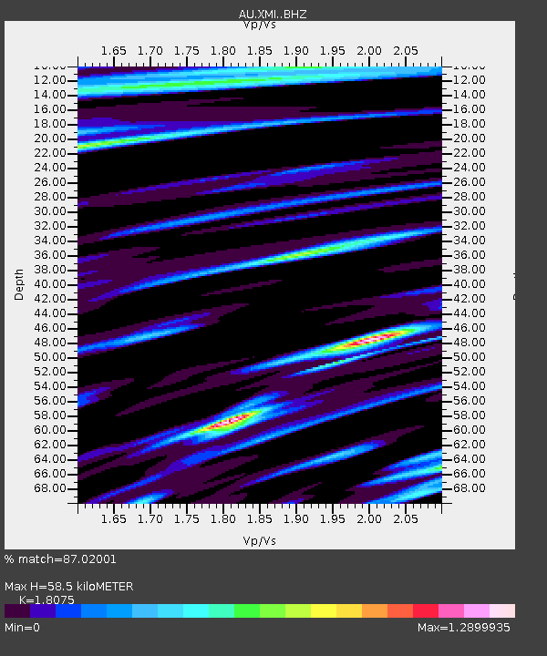
XMI Christmas Island Airport - Earthquake Result Viewer
| Earthquake location: |
Loyalty Islands |
| Earthquake latitude/longitude: |
-21.7/168.7 |
| Earthquake time(UTC): |
2017/11/19 (323) 09:25:47 GMT |
| Earthquake Depth: |
4.0 km |
| Earthquake Magnitude: |
6.3 mww |
| Earthquake Catalog/Contributor: |
NEIC PDE/us |
|
| Network: |
AU Australian Seismological Centre |
| Station: |
XMI Christmas Island Airport |
| Lat/Lon: |
10.45 S/105.69 E |
| Elevation: |
252 m |
|
| Distance: |
61.2 deg |
| Az: |
269.747 deg |
| Baz: |
108.96 deg |
| Ray Param: |
0.061025746 |
| Estimated Moho Depth: |
58.5 km |
| Estimated Crust Vp/Vs: |
1.81 |
| Assumed Crust Vp: |
4.157 km/s |
| Estimated Crust Vs: |
2.3 km/s |
| Estimated Crust Poisson's Ratio: |
0.28 |
|
| Radial Match: |
87.02001 % |
| Radial Bump: |
400 |
| Transverse Match: |
86.166245 % |
| Transverse Bump: |
400 |
| SOD ConfigId: |
13570011 |
| Insert Time: |
2019-04-29 06:42:54.623 +0000 |
| GWidth: |
2.5 |
| Max Bumps: |
400 |
| Tol: |
0.001 |
|

Signal To Noise
| Channel | StoN | STA | LTA |
| AU:XMI: :BHZ:20171119T09:35:31.868999Z | 9.4391775 | 2.0533566E-6 | 2.1753553E-7 |
| AU:XMI: :BHN:20171119T09:35:31.868999Z | 1.2244018 | 2.769742E-7 | 2.2621184E-7 |
| AU:XMI: :BHE:20171119T09:35:31.868999Z | 2.7792382 | 1.1509843E-6 | 4.141366E-7 |
| Arrivals |
| Ps | 12 SECOND |
| PpPs | 39 SECOND |
| PsPs/PpSs | 50 SECOND |


