You are here: Home > Network List > CI - Caltech Regional Seismic Network Stations List
> Station SMM Simmler, CA, USA > Earthquake Result Viewer
SMM Simmler, CA, USA - Earthquake Result Viewer
*The percent match for this event was below the threshold and hence no stack was calculated.
| Earthquake location: |
Loyalty Islands |
| Earthquake latitude/longitude: |
-21.7/168.7 |
| Earthquake time(UTC): |
2017/11/19 (323) 09:25:47 GMT |
| Earthquake Depth: |
4.0 km |
| Earthquake Magnitude: |
6.3 mww |
| Earthquake Catalog/Contributor: |
NEIC PDE/us |
|
| Network: |
CI Caltech Regional Seismic Network |
| Station: |
SMM Simmler, CA, USA |
| Lat/Lon: |
35.31 N/120.00 W |
| Elevation: |
599 m |
|
| Distance: |
88.1 deg |
| Az: |
50.813 deg |
| Baz: |
241.844 deg |
| Ray Param: |
$rayparam |
*The percent match for this event was below the threshold and hence was not used in the summary stack. |
|
| Radial Match: |
70.49001 % |
| Radial Bump: |
400 |
| Transverse Match: |
66.525856 % |
| Transverse Bump: |
400 |
| SOD ConfigId: |
13570011 |
| Insert Time: |
2019-04-29 06:44:47.868 +0000 |
| GWidth: |
2.5 |
| Max Bumps: |
400 |
| Tol: |
0.001 |
|
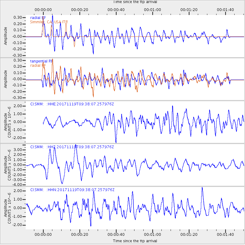
Signal To Noise
| Channel | StoN | STA | LTA |
| CI:SMM: :HHZ:20171119T09:38:07.257976Z | 7.1526375 | 1.67097E-6 | 2.3361592E-7 |
| CI:SMM: :HHN:20171119T09:38:07.257976Z | 0.76905364 | 1.9662359E-7 | 2.5566953E-7 |
| CI:SMM: :HHE:20171119T09:38:07.257976Z | 1.4861157 | 5.1977486E-7 | 3.4975398E-7 |
| Arrivals |
| Ps | |
| PpPs | |
| PsPs/PpSs | |


