You are here: Home > Network List > NN - Western Great Basin/Eastern Sierra Nevada Stations List
> Station WAK Walker, California w84 > Earthquake Result Viewer
WAK Walker, California w84 - Earthquake Result Viewer
| Earthquake location: |
Loyalty Islands |
| Earthquake latitude/longitude: |
-21.7/168.7 |
| Earthquake time(UTC): |
2017/11/19 (323) 09:25:47 GMT |
| Earthquake Depth: |
4.0 km |
| Earthquake Magnitude: |
6.3 mww |
| Earthquake Catalog/Contributor: |
NEIC PDE/us |
|
| Network: |
NN Western Great Basin/Eastern Sierra Nevada |
| Station: |
WAK Walker, California w84 |
| Lat/Lon: |
38.50 N/119.44 W |
| Elevation: |
1890 m |
|
| Distance: |
90.0 deg |
| Az: |
48.211 deg |
| Baz: |
242.135 deg |
| Ray Param: |
0.041704576 |
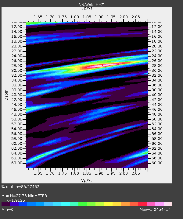
| Estimated Moho Depth: |
27.75 km |
| Estimated Crust Vp/Vs: |
1.91 |
| Assumed Crust Vp: |
6.279 km/s |
| Estimated Crust Vs: |
3.283 km/s |
| Estimated Crust Poisson's Ratio: |
0.31 |
|
| Radial Match: |
85.27462 % |
| Radial Bump: |
314 |
| Transverse Match: |
72.71279 % |
| Transverse Bump: |
400 |
| SOD ConfigId: |
13570011 |
| Insert Time: |
2019-04-29 06:46:15.467 +0000 |
| GWidth: |
2.5 |
| Max Bumps: |
400 |
| Tol: |
0.001 |
|

Signal To Noise
| Channel | StoN | STA | LTA |
| NN:WAK: :HHZ:20171119T09:38:16.105022Z | 11.252939 | 1.2844218E-6 | 1.1414102E-7 |
| NN:WAK: :HHN:20171119T09:38:16.105022Z | 0.6929843 | 1.2231558E-7 | 1.7650557E-7 |
| NN:WAK: :HHE:20171119T09:38:16.105022Z | 3.4489074 | 4.7107127E-7 | 1.3658565E-7 |
| Arrivals |
| Ps | 4.1 SECOND |
| PpPs | 13 SECOND |
| PsPs/PpSs | 17 SECOND |


