You are here: Home > Network List > TA - USArray Transportable Network (new EarthScope stations) Stations List
> Station J20K Nowitna River, AK, USA > Earthquake Result Viewer
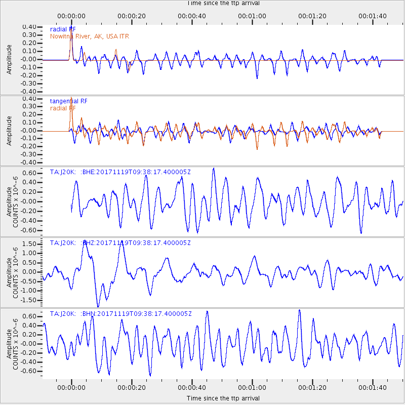
J20K Nowitna River, AK, USA - Earthquake Result Viewer
*The percent match for this event was below the threshold and hence no stack was calculated.
| Earthquake location: |
Loyalty Islands |
| Earthquake latitude/longitude: |
-21.7/168.7 |
| Earthquake time(UTC): |
2017/11/19 (323) 09:25:47 GMT |
| Earthquake Depth: |
4.0 km |
| Earthquake Magnitude: |
6.3 mww |
| Earthquake Catalog/Contributor: |
NEIC PDE/us |
|
| Network: |
TA USArray Transportable Network (new EarthScope stations) |
| Station: |
J20K Nowitna River, AK, USA |
| Lat/Lon: |
64.18 N/154.15 W |
| Elevation: |
314 m |
|
| Distance: |
90.3 deg |
| Az: |
15.338 deg |
| Baz: |
214.184 deg |
| Ray Param: |
$rayparam |
*The percent match for this event was below the threshold and hence was not used in the summary stack. |
|
| Radial Match: |
64.026436 % |
| Radial Bump: |
378 |
| Transverse Match: |
51.529026 % |
| Transverse Bump: |
400 |
| SOD ConfigId: |
13570011 |
| Insert Time: |
2019-04-29 06:47:49.290 +0000 |
| GWidth: |
2.5 |
| Max Bumps: |
400 |
| Tol: |
0.001 |
|
Signal To Noise
| Channel | StoN | STA | LTA |
| TA:J20K: :BHZ:20171119T09:38:17.400005Z | 3.635596 | 8.592497E-7 | 2.3634357E-7 |
| TA:J20K: :BHN:20171119T09:38:17.400005Z | 0.9760344 | 2.4293095E-7 | 2.4889587E-7 |
| TA:J20K: :BHE:20171119T09:38:17.400005Z | 0.6565506 | 1.4521373E-7 | 2.2117676E-7 |
| Arrivals |
| Ps | |
| PpPs | |
| PsPs/PpSs | |


