You are here: Home > Network List > TA - USArray Transportable Network (new EarthScope stations) Stations List
> Station J25K Salcha River, AK, USA > Earthquake Result Viewer
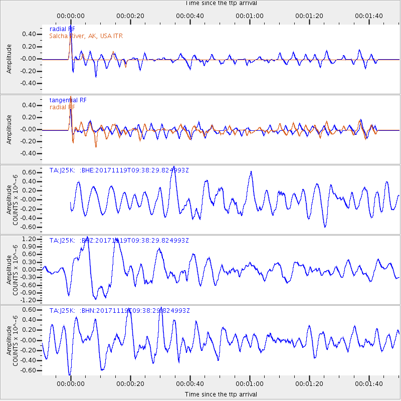
J25K Salcha River, AK, USA - Earthquake Result Viewer
*The percent match for this event was below the threshold and hence no stack was calculated.
| Earthquake location: |
Loyalty Islands |
| Earthquake latitude/longitude: |
-21.7/168.7 |
| Earthquake time(UTC): |
2017/11/19 (323) 09:25:47 GMT |
| Earthquake Depth: |
4.0 km |
| Earthquake Magnitude: |
6.3 mww |
| Earthquake Catalog/Contributor: |
NEIC PDE/us |
|
| Network: |
TA USArray Transportable Network (new EarthScope stations) |
| Station: |
J25K Salcha River, AK, USA |
| Lat/Lon: |
64.61 N/145.37 W |
| Elevation: |
949 m |
|
| Distance: |
93.0 deg |
| Az: |
18.069 deg |
| Baz: |
222.014 deg |
| Ray Param: |
$rayparam |
*The percent match for this event was below the threshold and hence was not used in the summary stack. |
|
| Radial Match: |
68.37573 % |
| Radial Bump: |
400 |
| Transverse Match: |
52.01592 % |
| Transverse Bump: |
400 |
| SOD ConfigId: |
13570011 |
| Insert Time: |
2019-04-29 06:47:49.453 +0000 |
| GWidth: |
2.5 |
| Max Bumps: |
400 |
| Tol: |
0.001 |
|
Signal To Noise
| Channel | StoN | STA | LTA |
| TA:J25K: :BHZ:20171119T09:38:29.824993Z | 4.4633703 | 6.8637263E-7 | 1.53779E-7 |
| TA:J25K: :BHN:20171119T09:38:29.824993Z | 2.3024423 | 3.584004E-7 | 1.5566097E-7 |
| TA:J25K: :BHE:20171119T09:38:29.824993Z | 1.8630861 | 3.697215E-7 | 1.9844575E-7 |
| Arrivals |
| Ps | |
| PpPs | |
| PsPs/PpSs | |


