B13A Whitefish, MT, USA - Earthquake Result Viewer
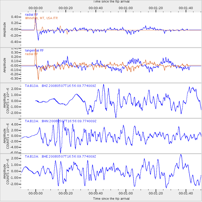
Earthquake location: Near East Coast Of Honshu, Japan
Earthquake latitude/longitude: 36.2/141.5
Earthquake time(UTC): 2008/05/07 (128) 16:45:20 GMT
Earthquake Depth: 39 km
Earthquake Magnitude: 6.1 MB, 6.7 MS, 6.8 MW, 6.8 MW
Earthquake Catalog/Contributor: WHDF/NEIC
Network: TA USArray Transportable Network (new EarthScope stations)
Station: B13A Whitefish, MT, USA
Lat/Lon: 48.37 N/114.47 W
Elevation: 933 m
Distance: 72.1 deg
Az: 42.826 deg
Baz: 304.403 deg
Ray Param: 0.05381184
Estimated Moho Depth: 62.25 km
Estimated Crust Vp/Vs: 1.88
Assumed Crust Vp: 6.622 km/s
Estimated Crust Vs: 3.518 km/s
Estimated Crust Poisson's Ratio: 0.30
Radial Match: 83.35523 %
Radial Bump: 400
Transverse Match: 81.69581 %
Transverse Bump: 369
SOD ConfigId: 2504
Insert Time: 2010-03-06 06:47:33.453 +0000
GWidth: 2.5
Max Bumps: 400
Tol: 0.001

Signal To Noise

ChannelStoNSTALTA
TA:B13A: :BHN:20080507T16:56:09.774009Z3.89183741.4507992E-63.7278002E-7
TA:B13A: :BHE:20080507T16:56:09.774009Z0.88171153.7626643E-74.2674554E-7
TA:B13A: :BHZ:20080507T16:56:09.774009Z2.8628518.614161E-73.008945E-7
Arrivals
Ps8.6 SECOND
PpPs26 SECOND
PsPs/PpSs35 SECOND