You are here: Home > Network List > TA - USArray Transportable Network (new EarthScope stations) Stations List
> Station B13A Whitefish, MT, USA > Earthquake Result Viewer
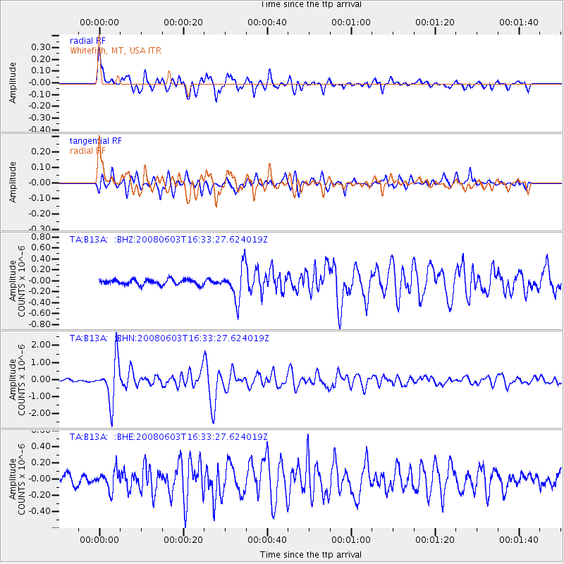
B13A Whitefish, MT, USA - Earthquake Result Viewer

| Earthquake location: |
Solomon Islands |
| Earthquake latitude/longitude: |
-10.5/161.3 |
| Earthquake time(UTC): |
2008/06/03 (155) 16:20:50 GMT |
| Earthquake Depth: |
84 km |
| Earthquake Magnitude: |
6.2 MB, 6.2 MW, 6.2 MW |
| Earthquake Catalog/Contributor: |
WHDF/NEIC |
|
| Network: |
TA USArray Transportable Network (new EarthScope stations) |
| Station: |
B13A Whitefish, MT, USA |
| Lat/Lon: |
48.37 N/114.47 W |
| Elevation: |
933 m |
|
| Distance: |
94.0 deg |
| Az: |
41.684 deg |
| Baz: |
258.778 deg |
| Ray Param: |
0.041099105 |
| Estimated Moho Depth: |
41.25 km |
| Estimated Crust Vp/Vs: |
1.87 |
| Assumed Crust Vp: |
6.622 km/s |
| Estimated Crust Vs: |
3.541 km/s |
| Estimated Crust Poisson's Ratio: |
0.30 |
|
| Radial Match: |
90.11559 % |
| Radial Bump: |
400 |
| Transverse Match: |
88.51553 % |
| Transverse Bump: |
400 |
| SOD ConfigId: |
2504 |
| Insert Time: |
2010-03-06 06:47:46.453 +0000 |
| GWidth: |
2.5 |
| Max Bumps: |
400 |
| Tol: |
0.001 |
|
Signal To Noise
| Channel | StoN | STA | LTA |
| TA:B13A: :BHN:20080603T16:33:27.624019Z | 24.709265 | 1.2385912E-6 | 5.0126587E-8 |
| TA:B13A: :BHE:20080603T16:33:27.624019Z | 2.2598543 | 1.1998665E-7 | 5.3094865E-8 |
| TA:B13A: :BHZ:20080603T16:33:27.624019Z | 6.4126954 | 3.0539903E-7 | 4.762413E-8 |
| Arrivals |
| Ps | 5.5 SECOND |
| PpPs | 18 SECOND |
| PsPs/PpSs | 23 SECOND |


