You are here: Home > Network List > TA - USArray Transportable Network (new EarthScope stations) Stations List
> Station B13A Whitefish, MT, USA > Earthquake Result Viewer
B13A Whitefish, MT, USA - Earthquake Result Viewer

| Earthquake location: |
Primor'ye, Russia |
| Earthquake latitude/longitude: |
45.2/137.4 |
| Earthquake time(UTC): |
2008/06/29 (181) 20:53:01 GMT |
| Earthquake Depth: |
287 km |
| Earthquake Magnitude: |
5.6 MB, 6.0 MW, 5.9 MW |
| Earthquake Catalog/Contributor: |
WHDF/NEIC |
|
| Network: |
TA USArray Transportable Network (new EarthScope stations) |
| Station: |
B13A Whitefish, MT, USA |
| Lat/Lon: |
48.37 N/114.47 W |
| Elevation: |
933 m |
|
| Distance: |
67.7 deg |
| Az: |
43.246 deg |
| Baz: |
313.365 deg |
| Ray Param: |
0.0559409 |
| Estimated Moho Depth: |
51.75 km |
| Estimated Crust Vp/Vs: |
1.60 |
| Assumed Crust Vp: |
6.622 km/s |
| Estimated Crust Vs: |
4.139 km/s |
| Estimated Crust Poisson's Ratio: |
0.18 |
|
| Radial Match: |
80.4507 % |
| Radial Bump: |
400 |
| Transverse Match: |
75.02427 % |
| Transverse Bump: |
400 |
| SOD ConfigId: |
2504 |
| Insert Time: |
2010-03-06 06:47:59.682 +0000 |
| GWidth: |
2.5 |
| Max Bumps: |
400 |
| Tol: |
0.001 |
|
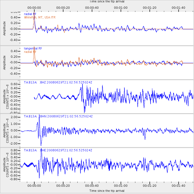
Signal To Noise
| Channel | StoN | STA | LTA |
| TA:B13A: :BHN:20080629T21:02:56.525024Z | 10.896794 | 9.835818E-7 | 9.0263406E-8 |
| TA:B13A: :BHE:20080629T21:02:56.525024Z | 4.9932866 | 3.1587447E-7 | 6.3259826E-8 |
| TA:B13A: :BHZ:20080629T21:02:56.525024Z | 4.4742737 | 2.956771E-7 | 6.608382E-8 |
| Arrivals |
| Ps | 4.9 SECOND |
| PpPs | 19 SECOND |
| PsPs/PpSs | 24 SECOND |


