You are here: Home > Network List > UW - Pacific Northwest Regional Seismic Network Stations List
> Station LCCR Mulino, OR, USA > Earthquake Result Viewer
LCCR Mulino, OR, USA - Earthquake Result Viewer
*The percent match for this event was below the threshold and hence no stack was calculated.
| Earthquake location: |
Loyalty Islands |
| Earthquake latitude/longitude: |
-21.7/168.7 |
| Earthquake time(UTC): |
2017/11/19 (323) 09:25:47 GMT |
| Earthquake Depth: |
4.0 km |
| Earthquake Magnitude: |
6.3 mww |
| Earthquake Catalog/Contributor: |
NEIC PDE/us |
|
| Network: |
UW Pacific Northwest Regional Seismic Network |
| Station: |
LCCR Mulino, OR, USA |
| Lat/Lon: |
45.21 N/122.48 W |
| Elevation: |
273 m |
|
| Distance: |
91.3 deg |
| Az: |
41.251 deg |
| Baz: |
240.187 deg |
| Ray Param: |
$rayparam |
*The percent match for this event was below the threshold and hence was not used in the summary stack. |
|
| Radial Match: |
60.34879 % |
| Radial Bump: |
400 |
| Transverse Match: |
61.296207 % |
| Transverse Bump: |
400 |
| SOD ConfigId: |
13570011 |
| Insert Time: |
2019-04-29 06:49:32.432 +0000 |
| GWidth: |
2.5 |
| Max Bumps: |
400 |
| Tol: |
0.001 |
|
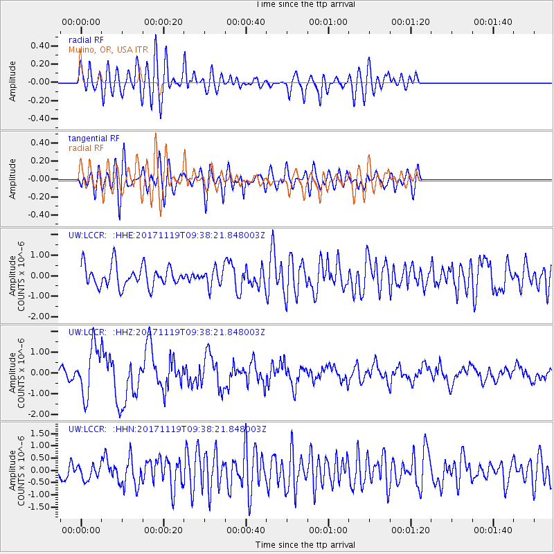
Signal To Noise
| Channel | StoN | STA | LTA |
| UW:LCCR: :HHZ:20171119T09:38:21.848003Z | 4.289178 | 1.2098441E-6 | 2.8206898E-7 |
| UW:LCCR: :HHN:20171119T09:38:21.848003Z | 0.87466294 | 2.8882457E-7 | 3.3021243E-7 |
| UW:LCCR: :HHE:20171119T09:38:21.848003Z | 0.84446365 | 4.3277262E-7 | 5.1248225E-7 |
| Arrivals |
| Ps | |
| PpPs | |
| PsPs/PpSs | |


