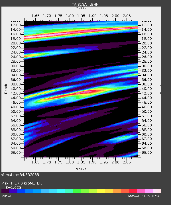
B13A Whitefish, MT, USA - Earthquake Result Viewer
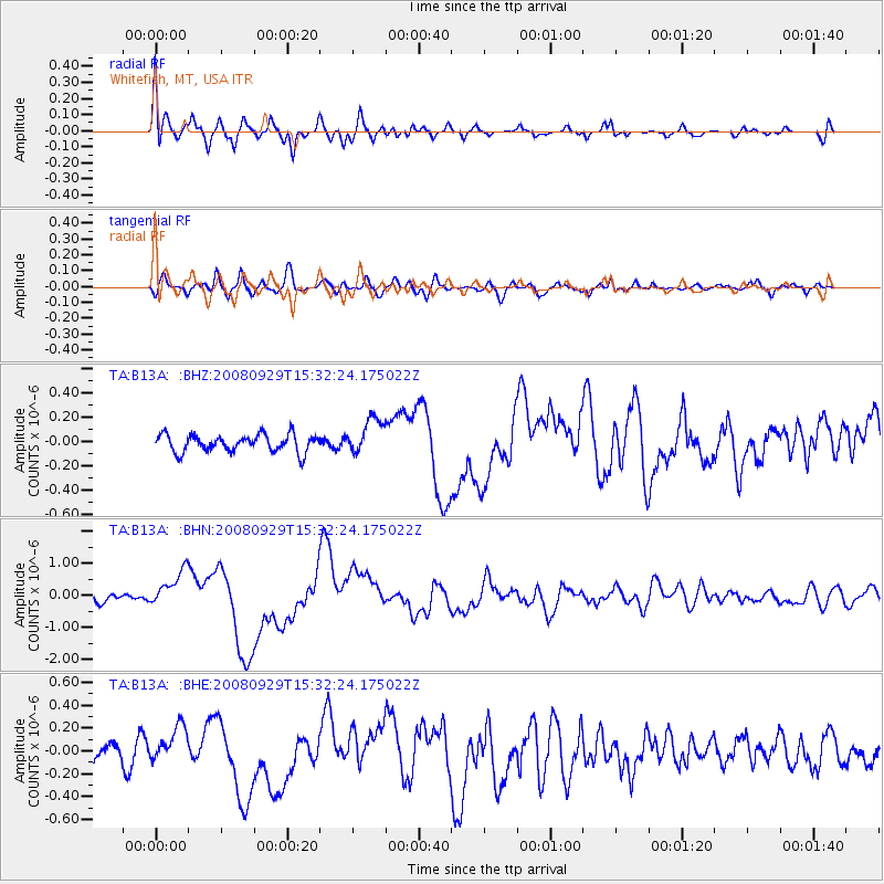
Earthquake location: Kermadec Islands, New Zealand
Earthquake latitude/longitude: -29.8/-177.7
Earthquake time(UTC): 2008/09/29 (273) 15:19:31 GMT
Earthquake Depth: 36 km
Earthquake Magnitude: 6.5 MB, 6.7 MS, 7.0 MW, 7.0 MW
Earthquake Catalog/Contributor: WHDF/NEIC
Network: TA USArray Transportable Network (new EarthScope stations)
Station: B13A Whitefish, MT, USA
Lat/Lon: 48.37 N/114.47 W
Elevation: 933 m
Distance: 96.1 deg
Az: 36.772 deg
Baz: 231.328 deg
Ray Param: 0.040582772
Estimated Moho Depth: 17.0 km
Estimated Crust Vp/Vs: 1.62
Assumed Crust Vp: 6.622 km/s
Estimated Crust Vs: 4.075 km/s
Estimated Crust Poisson's Ratio: 0.20
Radial Match: 84.632965 %
Radial Bump: 400
Transverse Match: 70.144325 %
Transverse Bump: 400
SOD ConfigId: 2560
Insert Time: 2010-03-06 06:48:44.442 +0000
GWidth: 2.5
Max Bumps: 400
Tol: 0.001

Signal To Noise

ChannelStoNSTALTA
TA:B13A: :BHN:20080929T15:32:24.175022Z5.51535945.6954855E-71.032659E-7
TA:B13A: :BHE:20080929T15:32:24.175022Z1.6234671.6483794E-71.0153452E-7
TA:B13A: :BHZ:20080929T15:32:24.175022Z2.07381531.4711208E-77.093789E-8
Arrivals
Ps1.6 SECOND
PpPs6.6 SECOND
PsPs/PpSs8.2 SECOND