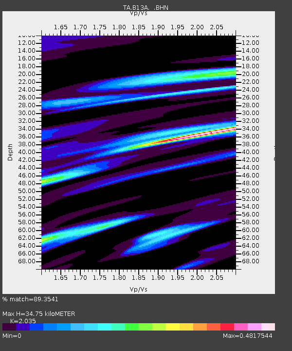
B13A Whitefish, MT, USA - Earthquake Result Viewer
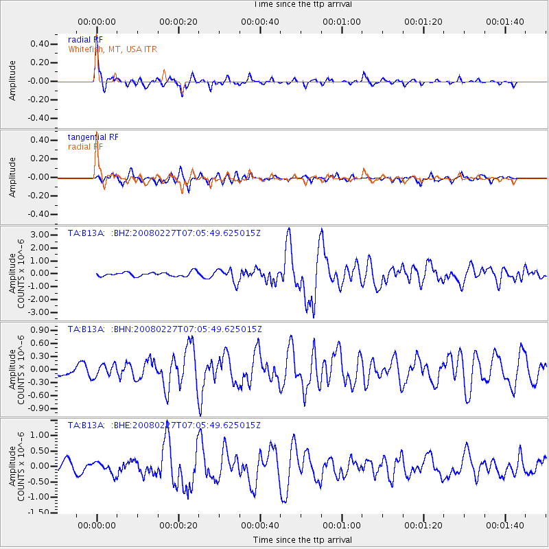
Earthquake location: Bonin Islands, Japan Region
Earthquake latitude/longitude: 26.8/142.4
Earthquake time(UTC): 2008/02/27 (058) 06:54:20 GMT
Earthquake Depth: 15 km
Earthquake Magnitude: 5.8 MB, 6.1 MS, 6.2 MW, 6.2 MW
Earthquake Catalog/Contributor: WHDF/NEIC
Network: TA USArray Transportable Network (new EarthScope stations)
Station: B13A Whitefish, MT, USA
Lat/Lon: 48.37 N/114.47 W
Elevation: 933 m
Distance: 78.5 deg
Az: 41.509 deg
Baz: 297.342 deg
Ray Param: 0.049592145
Estimated Moho Depth: 34.75 km
Estimated Crust Vp/Vs: 2.04
Assumed Crust Vp: 6.622 km/s
Estimated Crust Vs: 3.254 km/s
Estimated Crust Poisson's Ratio: 0.34
Radial Match: 89.3541 %
Radial Bump: 292
Transverse Match: 81.89785 %
Transverse Bump: 400
SOD ConfigId: 2564
Insert Time: 2010-03-06 06:48:47.950 +0000
GWidth: 2.5
Max Bumps: 400
Tol: 0.001

Signal To Noise

ChannelStoNSTALTA
TA:B13A: :BHN:20080227T07:05:49.625015Z0.80429061.3479419E-71.675939E-7
TA:B13A: :BHE:20080227T07:05:49.625015Z1.33961761.93158E-71.4418892E-7
TA:B13A: :BHZ:20080227T07:05:49.625015Z3.3613915.3439305E-71.5897973E-7
Arrivals
Ps5.6 SECOND
PpPs15 SECOND
PsPs/PpSs21 SECOND