You are here: Home > Network List > TA - USArray Transportable Network (new EarthScope stations) Stations List
> Station B13A Whitefish, MT, USA > Earthquake Result Viewer
B13A Whitefish, MT, USA - Earthquake Result Viewer
| Earthquake location: |
Windward Islands |
| Earthquake latitude/longitude: |
15.0/-61.3 |
| Earthquake time(UTC): |
2007/11/29 (333) 19:00:19 GMT |
| Earthquake Depth: |
148 km |
| Earthquake Magnitude: |
6.9 MB, 7.4 MW, 7.4 MW |
| Earthquake Catalog/Contributor: |
WHDF/NEIC |
|
| Network: |
TA USArray Transportable Network (new EarthScope stations) |
| Station: |
B13A Whitefish, MT, USA |
| Lat/Lon: |
48.37 N/114.47 W |
| Elevation: |
933 m |
|
| Distance: |
54.7 deg |
| Az: |
319.163 deg |
| Baz: |
108.585 deg |
| Ray Param: |
0.06476717 |
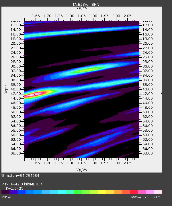
| Estimated Moho Depth: |
42.0 km |
| Estimated Crust Vp/Vs: |
1.64 |
| Assumed Crust Vp: |
6.622 km/s |
| Estimated Crust Vs: |
4.032 km/s |
| Estimated Crust Poisson's Ratio: |
0.21 |
|
| Radial Match: |
84.784584 % |
| Radial Bump: |
400 |
| Transverse Match: |
70.94685 % |
| Transverse Bump: |
400 |
| SOD ConfigId: |
2564 |
| Insert Time: |
2010-03-06 06:49:16.147 +0000 |
| GWidth: |
2.5 |
| Max Bumps: |
400 |
| Tol: |
0.001 |
|
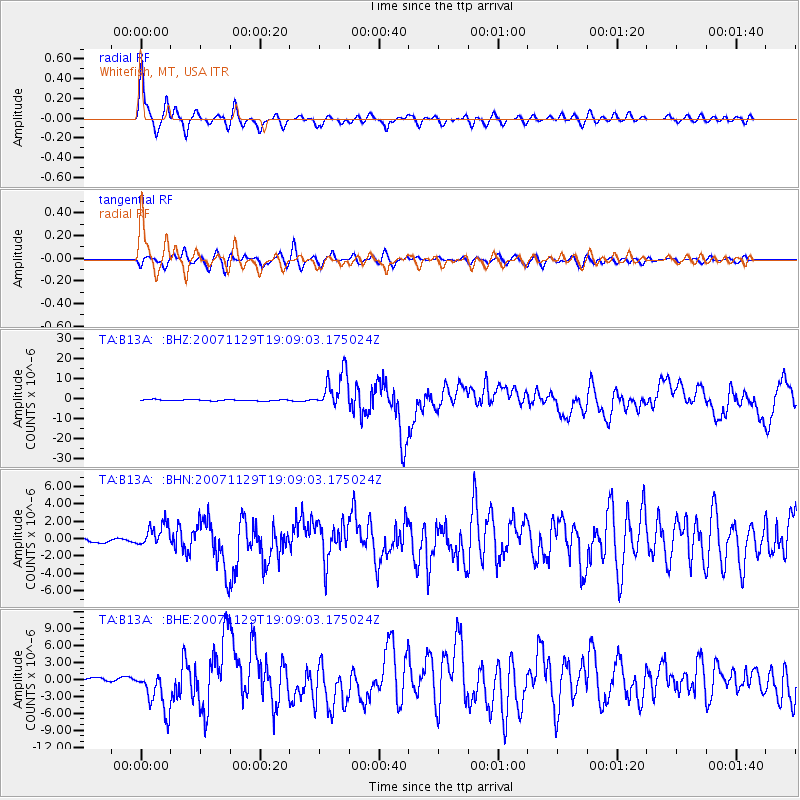
Signal To Noise
| Channel | StoN | STA | LTA |
| TA:B13A: :BHN:20071129T19:09:03.175024Z | 4.5491023 | 1.3185627E-6 | 2.8985122E-7 |
| TA:B13A: :BHE:20071129T19:09:03.175024Z | 12.238631 | 3.7887228E-6 | 3.0957082E-7 |
| TA:B13A: :BHZ:20071129T19:09:03.175024Z | 29.892483 | 9.109748E-6 | 3.0475047E-7 |
| Arrivals |
| Ps | 4.3 SECOND |
| PpPs | 16 SECOND |
| PsPs/PpSs | 20 SECOND |


