You are here: Home > Network List > AU - Australian Seismological Centre Stations List
> Station XMI Christmas Island Airport > Earthquake Result Viewer
XMI Christmas Island Airport - Earthquake Result Viewer
| Earthquake location: |
Loyalty Islands |
| Earthquake latitude/longitude: |
-21.5/168.5 |
| Earthquake time(UTC): |
2017/11/19 (323) 15:09:03 GMT |
| Earthquake Depth: |
14 km |
| Earthquake Magnitude: |
6.6 mww |
| Earthquake Catalog/Contributor: |
NEIC PDE/us |
|
| Network: |
AU Australian Seismological Centre |
| Station: |
XMI Christmas Island Airport |
| Lat/Lon: |
10.45 S/105.69 E |
| Elevation: |
252 m |
|
| Distance: |
61.1 deg |
| Az: |
269.728 deg |
| Baz: |
108.803 deg |
| Ray Param: |
0.06109887 |
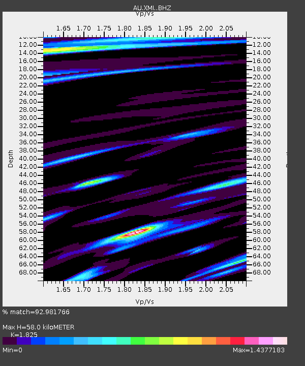
| Estimated Moho Depth: |
58.0 km |
| Estimated Crust Vp/Vs: |
1.83 |
| Assumed Crust Vp: |
4.157 km/s |
| Estimated Crust Vs: |
2.278 km/s |
| Estimated Crust Poisson's Ratio: |
0.29 |
|
| Radial Match: |
92.981766 % |
| Radial Bump: |
400 |
| Transverse Match: |
89.62469 % |
| Transverse Bump: |
400 |
| SOD ConfigId: |
13570011 |
| Insert Time: |
2019-04-29 06:51:59.873 +0000 |
| GWidth: |
2.5 |
| Max Bumps: |
400 |
| Tol: |
0.001 |
|

Signal To Noise
| Channel | StoN | STA | LTA |
| AU:XMI: :BHZ:20171119T15:18:45.518987Z | 2.3327608 | 7.771077E-7 | 3.331279E-7 |
| AU:XMI: :BHN:20171119T15:18:45.518987Z | 2.1638513 | 3.6018773E-7 | 1.664568E-7 |
| AU:XMI: :BHE:20171119T15:18:45.518987Z | 1.2510971 | 5.709034E-7 | 4.5632223E-7 |
| Arrivals |
| Ps | 12 SECOND |
| PpPs | 39 SECOND |
| PsPs/PpSs | 50 SECOND |


