You are here: Home > Network List > AZ - ANZA Regional Network Stations List
> Station SMER AZ.SMER > Earthquake Result Viewer
SMER AZ.SMER - Earthquake Result Viewer
*The percent match for this event was below the threshold and hence no stack was calculated.
| Earthquake location: |
Loyalty Islands |
| Earthquake latitude/longitude: |
-21.5/168.5 |
| Earthquake time(UTC): |
2017/11/19 (323) 15:09:03 GMT |
| Earthquake Depth: |
14 km |
| Earthquake Magnitude: |
6.6 mww |
| Earthquake Catalog/Contributor: |
NEIC PDE/us |
|
| Network: |
AZ ANZA Regional Network |
| Station: |
SMER AZ.SMER |
| Lat/Lon: |
33.46 N/117.17 W |
| Elevation: |
355 m |
|
| Distance: |
89.4 deg |
| Az: |
53.59 deg |
| Baz: |
243.689 deg |
| Ray Param: |
$rayparam |
*The percent match for this event was below the threshold and hence was not used in the summary stack. |
|
| Radial Match: |
56.444717 % |
| Radial Bump: |
400 |
| Transverse Match: |
57.492245 % |
| Transverse Bump: |
400 |
| SOD ConfigId: |
13570011 |
| Insert Time: |
2019-04-29 06:52:27.399 +0000 |
| GWidth: |
2.5 |
| Max Bumps: |
400 |
| Tol: |
0.001 |
|
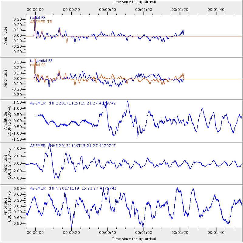
Signal To Noise
| Channel | StoN | STA | LTA |
| AZ:SMER: :HHZ:20171119T15:21:27.417974Z | 6.6908755 | 9.512414E-7 | 1.4216994E-7 |
| AZ:SMER: :HHN:20171119T15:21:27.417974Z | 0.6354147 | 3.852428E-7 | 6.0628554E-7 |
| AZ:SMER: :HHE:20171119T15:21:27.417974Z | 0.81446767 | 2.3087769E-7 | 2.8347065E-7 |
| Arrivals |
| Ps | |
| PpPs | |
| PsPs/PpSs | |


