You are here: Home > Network List > TA - USArray Transportable Network (new EarthScope stations) Stations List
> Station B13A Whitefish, MT, USA > Earthquake Result Viewer
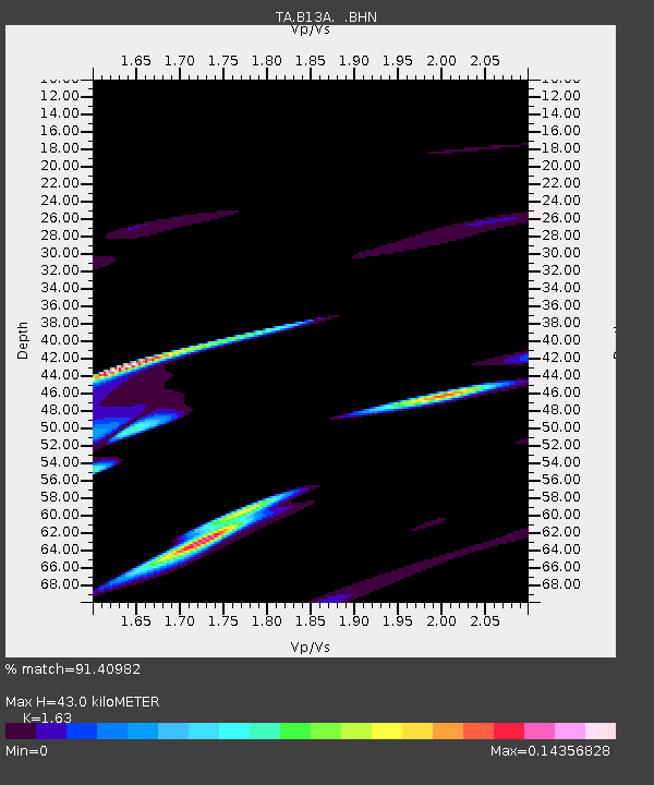
B13A Whitefish, MT, USA - Earthquake Result Viewer
| Earthquake location: |
Fox Islands, Aleutian Islands |
| Earthquake latitude/longitude: |
52.4/-168.0 |
| Earthquake time(UTC): |
2007/07/15 (196) 13:26:15 GMT |
| Earthquake Depth: |
10 km |
| Earthquake Magnitude: |
5.6 MB, 5.8 MW, 5.7 ML |
| Earthquake Catalog/Contributor: |
WHDF/NEIC |
|
| Network: |
TA USArray Transportable Network (new EarthScope stations) |
| Station: |
B13A Whitefish, MT, USA |
| Lat/Lon: |
48.37 N/114.47 W |
| Elevation: |
933 m |
|
| Distance: |
33.7 deg |
| Az: |
74.963 deg |
| Baz: |
297.346 deg |
| Ray Param: |
0.078073435 |
| Estimated Moho Depth: |
43.0 km |
| Estimated Crust Vp/Vs: |
1.63 |
| Assumed Crust Vp: |
6.622 km/s |
| Estimated Crust Vs: |
4.063 km/s |
| Estimated Crust Poisson's Ratio: |
0.20 |
|
| Radial Match: |
91.40982 % |
| Radial Bump: |
400 |
| Transverse Match: |
79.105156 % |
| Transverse Bump: |
400 |
| SOD ConfigId: |
2564 |
| Insert Time: |
2010-03-06 06:50:02.961 +0000 |
| GWidth: |
2.5 |
| Max Bumps: |
400 |
| Tol: |
0.001 |
|

Signal To Noise
| Channel | StoN | STA | LTA |
| TA:B13A: :BHN:20070715T13:32:25.949015Z | 0.92266315 | 9.227363E-7 | 1.0000794E-6 |
| TA:B13A: :BHE:20070715T13:32:25.949015Z | 1.628511 | 4.789738E-6 | 2.9411763E-6 |
| TA:B13A: :BHZ:20070715T13:32:25.949015Z | 1.9432312 | 4.6210844E-6 | 2.3780415E-6 |
| Arrivals |
| Ps | 4.5 SECOND |
| PpPs | 16 SECOND |
| PsPs/PpSs | 20 SECOND |


