You are here: Home > Network List > TA - USArray Transportable Network (new EarthScope stations) Stations List
> Station B13A Whitefish, MT, USA > Earthquake Result Viewer
B13A Whitefish, MT, USA - Earthquake Result Viewer
| Earthquake location: |
Kuril Islands |
| Earthquake latitude/longitude: |
46.0/151.4 |
| Earthquake time(UTC): |
2009/04/18 (108) 19:17:58 GMT |
| Earthquake Depth: |
35 km |
| Earthquake Magnitude: |
6.3 MB, 6.3 MS, 6.6 MW, 6.4 MW |
| Earthquake Catalog/Contributor: |
WHDF/NEIC |
|
| Network: |
TA USArray Transportable Network (new EarthScope stations) |
| Station: |
B13A Whitefish, MT, USA |
| Lat/Lon: |
48.37 N/114.47 W |
| Elevation: |
933 m |
|
| Distance: |
59.9 deg |
| Az: |
50.225 deg |
| Baz: |
306.555 deg |
| Ray Param: |
0.061811924 |
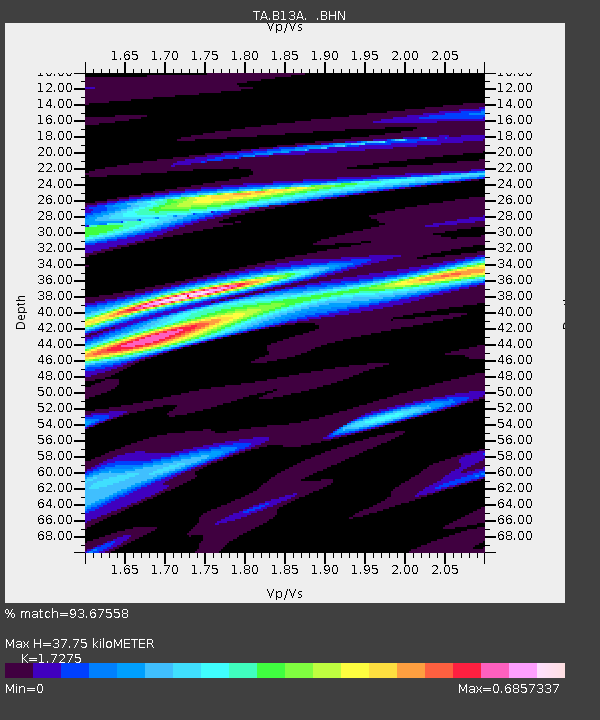
| Estimated Moho Depth: |
37.75 km |
| Estimated Crust Vp/Vs: |
1.73 |
| Assumed Crust Vp: |
6.622 km/s |
| Estimated Crust Vs: |
3.833 km/s |
| Estimated Crust Poisson's Ratio: |
0.25 |
|
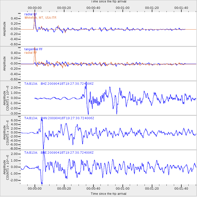
| Radial Match: |
93.67558 % |
| Radial Bump: |
378 |
| Transverse Match: |
84.31332 % |
| Transverse Bump: |
400 |
| SOD ConfigId: |
2658 |
| Insert Time: |
2010-03-06 06:50:23.441 +0000 |
| GWidth: |
2.5 |
| Max Bumps: |
400 |
| Tol: |
0.001 |
|
Signal To Noise
| Channel | StoN | STA | LTA |
| TA:B13A: :BHN:20090418T19:27:30.724006Z | 26.364569 | 2.4602848E-6 | 9.331785E-8 |
| TA:B13A: :BHE:20090418T19:27:30.724006Z | 3.8302586 | 7.92059E-7 | 2.0678995E-7 |
| TA:B13A: :BHZ:20090418T19:27:30.724006Z | 6.752252 | 8.117752E-7 | 1.2022288E-7 |
| Arrivals |
| Ps | 4.4 SECOND |
| PpPs | 15 SECOND |
| PsPs/PpSs | 19 SECOND |


