You are here: Home > Network List > TA - USArray Transportable Network (new EarthScope stations) Stations List
> Station B13A Whitefish, MT, USA > Earthquake Result Viewer
B13A Whitefish, MT, USA - Earthquake Result Viewer

| Earthquake location: |
New Ireland Region, P.N.G. |
| Earthquake latitude/longitude: |
-5.2/153.7 |
| Earthquake time(UTC): |
2009/06/23 (174) 14:19:17 GMT |
| Earthquake Depth: |
65 km |
| Earthquake Magnitude: |
5.5 MB |
| Earthquake Catalog/Contributor: |
WHDF/NEIC |
|
| Network: |
TA USArray Transportable Network (new EarthScope stations) |
| Station: |
B13A Whitefish, MT, USA |
| Lat/Lon: |
48.37 N/114.47 W |
| Elevation: |
933 m |
|
| Distance: |
95.1 deg |
| Az: |
41.992 deg |
| Baz: |
267.915 deg |
| Ray Param: |
0.040838856 |
| Estimated Moho Depth: |
41.75 km |
| Estimated Crust Vp/Vs: |
1.86 |
| Assumed Crust Vp: |
6.622 km/s |
| Estimated Crust Vs: |
3.57 km/s |
| Estimated Crust Poisson's Ratio: |
0.30 |
|
| Radial Match: |
88.120255 % |
| Radial Bump: |
400 |
| Transverse Match: |
87.276596 % |
| Transverse Bump: |
400 |
| SOD ConfigId: |
2648 |
| Insert Time: |
2010-03-06 06:50:37.248 +0000 |
| GWidth: |
2.5 |
| Max Bumps: |
400 |
| Tol: |
0.001 |
|
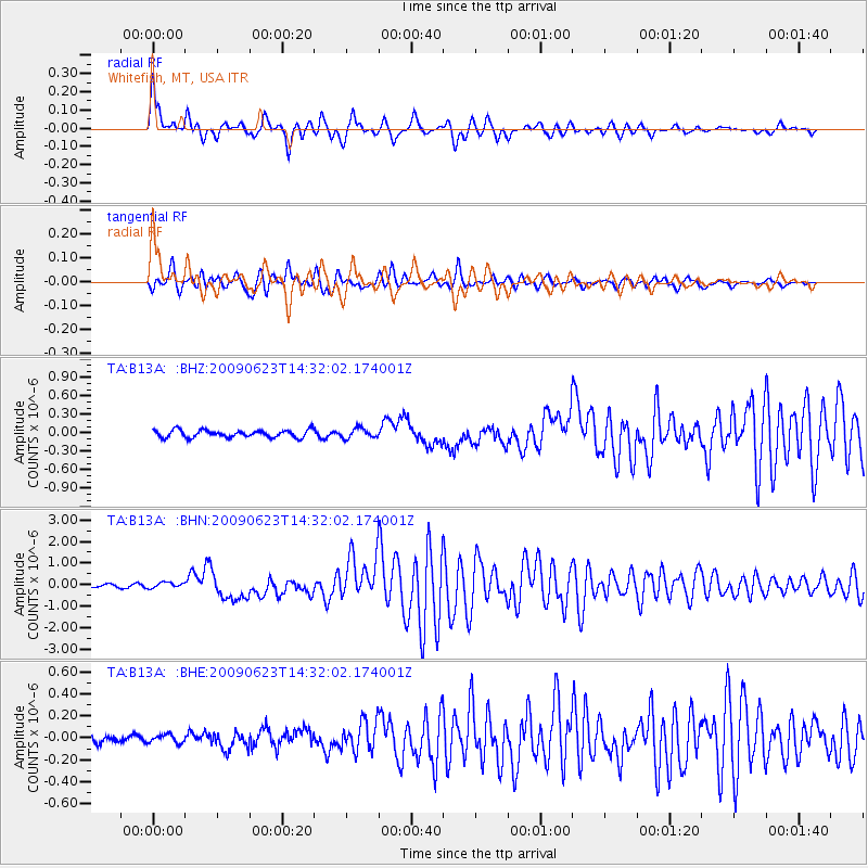
Signal To Noise
| Channel | StoN | STA | LTA |
| TA:B13A: :BHN:20090623T14:32:02.174001Z | 2.175684 | 1.2971569E-7 | 5.962065E-8 |
| TA:B13A: :BHE:20090623T14:32:02.174001Z | 0.84898835 | 3.7819632E-8 | 4.4546702E-8 |
| TA:B13A: :BHZ:20090623T14:32:02.174001Z | 1.3324335 | 7.959966E-8 | 5.974006E-8 |
| Arrivals |
| Ps | 5.5 SECOND |
| PpPs | 18 SECOND |
| PsPs/PpSs | 23 SECOND |


