You are here: Home > Network List > TA - USArray Transportable Network (new EarthScope stations) Stations List
> Station E18K Tukpahlearik Creek, AK, USA > Earthquake Result Viewer
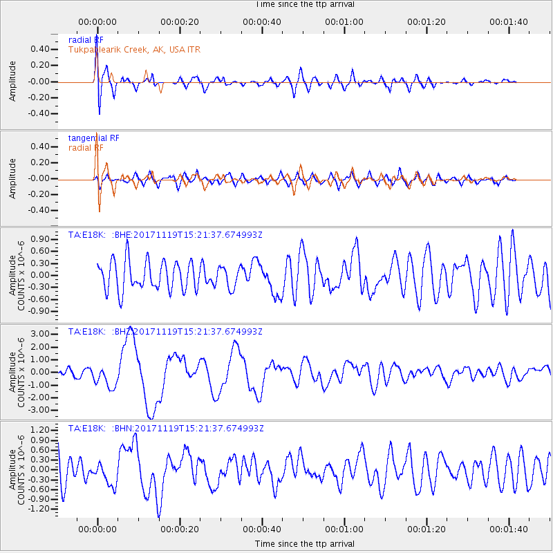
E18K Tukpahlearik Creek, AK, USA - Earthquake Result Viewer
*The percent match for this event was below the threshold and hence no stack was calculated.
| Earthquake location: |
Loyalty Islands |
| Earthquake latitude/longitude: |
-21.5/168.5 |
| Earthquake time(UTC): |
2017/11/19 (323) 15:09:03 GMT |
| Earthquake Depth: |
14 km |
| Earthquake Magnitude: |
6.6 mww |
| Earthquake Catalog/Contributor: |
NEIC PDE/us |
|
| Network: |
TA USArray Transportable Network (new EarthScope stations) |
| Station: |
E18K Tukpahlearik Creek, AK, USA |
| Lat/Lon: |
67.42 N/160.60 W |
| Elevation: |
297 m |
|
| Distance: |
91.6 deg |
| Az: |
11.427 deg |
| Baz: |
208.537 deg |
| Ray Param: |
$rayparam |
*The percent match for this event was below the threshold and hence was not used in the summary stack. |
|
| Radial Match: |
73.00207 % |
| Radial Bump: |
400 |
| Transverse Match: |
60.688583 % |
| Transverse Bump: |
400 |
| SOD ConfigId: |
13570011 |
| Insert Time: |
2019-04-29 06:55:50.562 +0000 |
| GWidth: |
2.5 |
| Max Bumps: |
400 |
| Tol: |
0.001 |
|
Signal To Noise
| Channel | StoN | STA | LTA |
| TA:E18K: :BHZ:20171119T15:21:37.674993Z | 2.4667904 | 8.760935E-7 | 3.5515524E-7 |
| TA:E18K: :BHN:20171119T15:21:37.674993Z | 0.9805826 | 3.5872193E-7 | 3.6582531E-7 |
| TA:E18K: :BHE:20171119T15:21:37.674993Z | 0.73867154 | 2.678256E-7 | 3.6257742E-7 |
| Arrivals |
| Ps | |
| PpPs | |
| PsPs/PpSs | |


