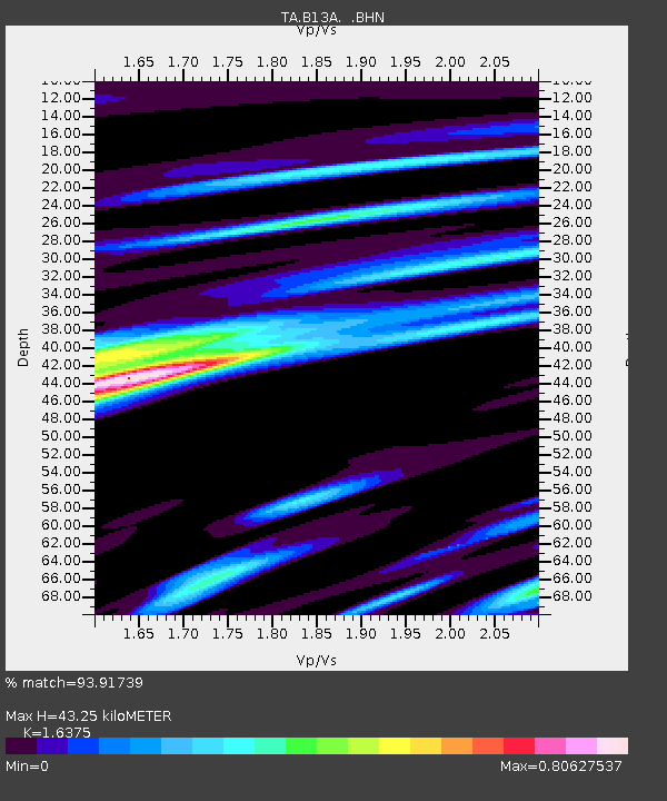
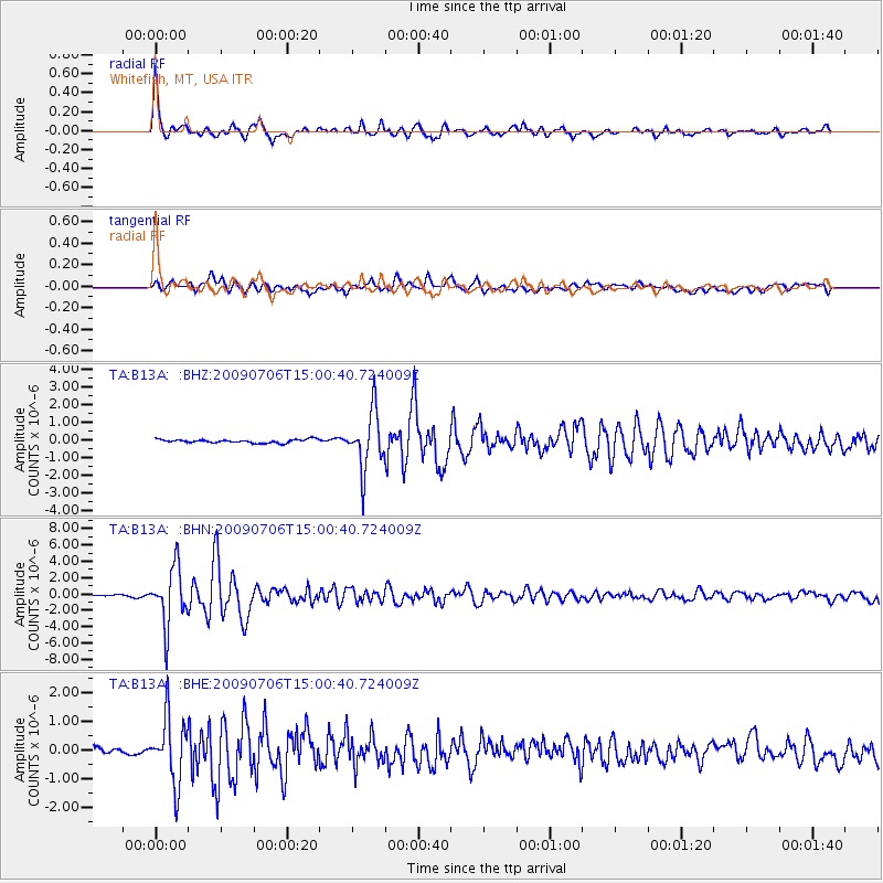
B13A Whitefish, MT, USA - Earthquake Result Viewer

Earthquake location: Rat Islands, Aleutian Islands
Earthquake latitude/longitude: 50.4/177.0
Earthquake time(UTC): 2009/07/06 (187) 14:53:12 GMT
Earthquake Depth: 22 km
Earthquake Magnitude: 6.0 MB, 5.8 MS, 6.1 MW, 6.0 MW
Earthquake Catalog/Contributor: WHDF/NEIC
Network: TA USArray Transportable Network (new EarthScope stations)
Station: B13A Whitefish, MT, USA
Lat/Lon: 48.37 N/114.47 W
Elevation: 933 m
Distance: 43.2 deg
Az: 65.022 deg
Baz: 299.61 deg
Ray Param: 0.072671555
Estimated Moho Depth: 43.25 km
Estimated Crust Vp/Vs: 1.64
Assumed Crust Vp: 6.622 km/s
Estimated Crust Vs: 4.044 km/s
Estimated Crust Poisson's Ratio: 0.20
Radial Match: 93.91739 %
Radial Bump: 398
Transverse Match: 84.37011 %
Transverse Bump: 400
SOD ConfigId: 2648
Insert Time: 2010-03-06 06:50:47.989 +0000
GWidth: 2.5
Max Bumps: 400
Tol: 0.001

Signal To Noise

ChannelStoNSTALTA
TA:B13A: :BHN:20090706T15:00:40.724009Z42.0977443.5158414E-68.351615E-8
TA:B13A: :BHE:20090706T15:00:40.724009Z14.7392391.1264742E-67.642689E-8
TA:B13A: :BHZ:20090706T15:00:40.724009Z16.6409131.6177094E-69.721278E-8
Arrivals
Ps4.5 SECOND
PpPs16 SECOND
PsPs/PpSs20 SECOND