You are here: Home > Network List > TA - USArray Transportable Network (new EarthScope stations) Stations List
> Station B13A Whitefish, MT, USA > Earthquake Result Viewer
B13A Whitefish, MT, USA - Earthquake Result Viewer
| Earthquake location: |
Southern Peru |
| Earthquake latitude/longitude: |
-15.0/-70.4 |
| Earthquake time(UTC): |
2009/07/12 (193) 06:12:47 GMT |
| Earthquake Depth: |
199 km |
| Earthquake Magnitude: |
5.7 MB, 6.1 MW, 6.1 MW |
| Earthquake Catalog/Contributor: |
WHDF/NEIC |
|
| Network: |
TA USArray Transportable Network (new EarthScope stations) |
| Station: |
B13A Whitefish, MT, USA |
| Lat/Lon: |
48.37 N/114.47 W |
| Elevation: |
933 m |
|
| Distance: |
74.3 deg |
| Az: |
331.225 deg |
| Baz: |
135.77 deg |
| Ray Param: |
0.051915415 |
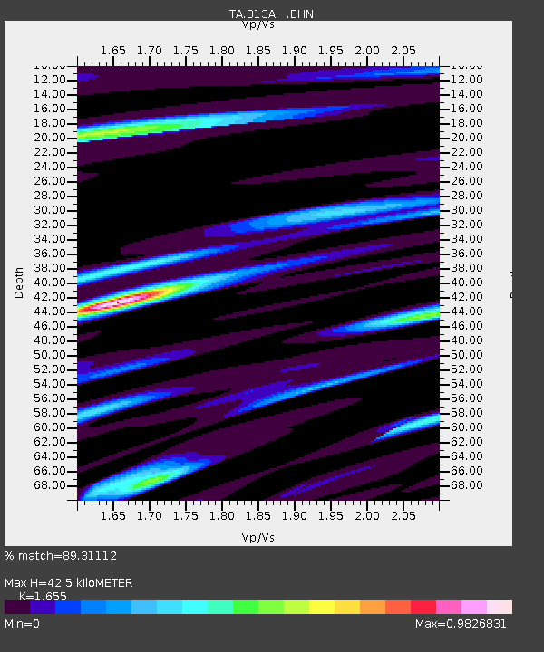
| Estimated Moho Depth: |
42.5 km |
| Estimated Crust Vp/Vs: |
1.65 |
| Assumed Crust Vp: |
6.622 km/s |
| Estimated Crust Vs: |
4.001 km/s |
| Estimated Crust Poisson's Ratio: |
0.21 |
|
| Radial Match: |
89.31112 % |
| Radial Bump: |
400 |
| Transverse Match: |
75.86915 % |
| Transverse Bump: |
400 |
| SOD ConfigId: |
2648 |
| Insert Time: |
2010-03-06 06:50:50.433 +0000 |
| GWidth: |
2.5 |
| Max Bumps: |
400 |
| Tol: |
0.001 |
|
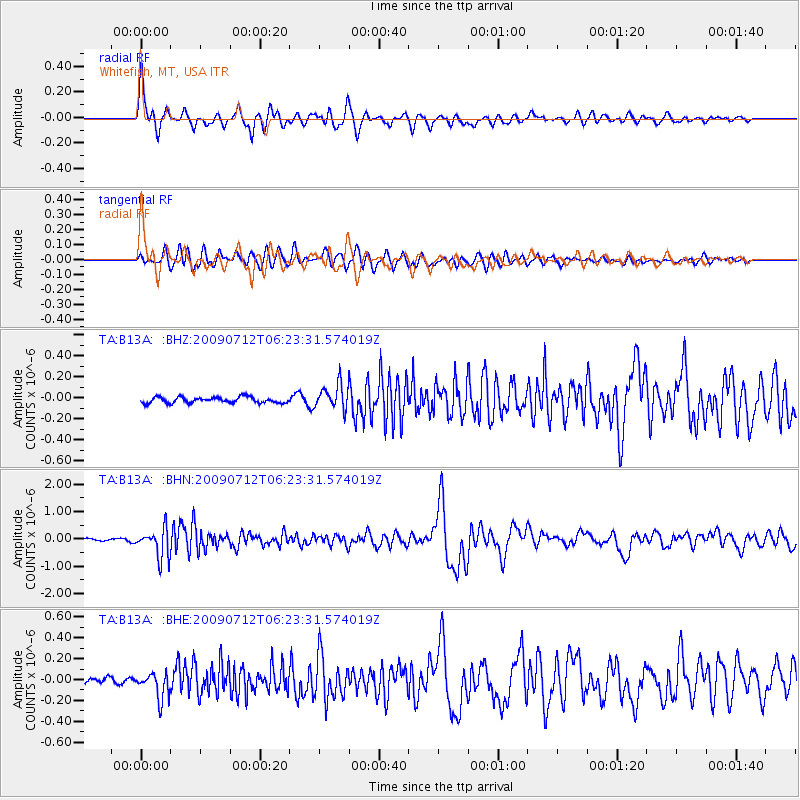
Signal To Noise
| Channel | StoN | STA | LTA |
| TA:B13A: :BHN:20090712T06:23:31.574019Z | 9.071292 | 5.26726E-7 | 5.806516E-8 |
| TA:B13A: :BHE:20090712T06:23:31.574019Z | 2.6689913 | 1.1781926E-7 | 4.414374E-8 |
| TA:B13A: :BHZ:20090712T06:23:31.574019Z | 4.2878613 | 1.1837578E-7 | 2.7607186E-8 |
| Arrivals |
| Ps | 4.4 SECOND |
| PpPs | 16 SECOND |
| PsPs/PpSs | 21 SECOND |


