You are here: Home > Network List > TA - USArray Transportable Network (new EarthScope stations) Stations List
> Station G31M Satah River, YT, CAN > Earthquake Result Viewer
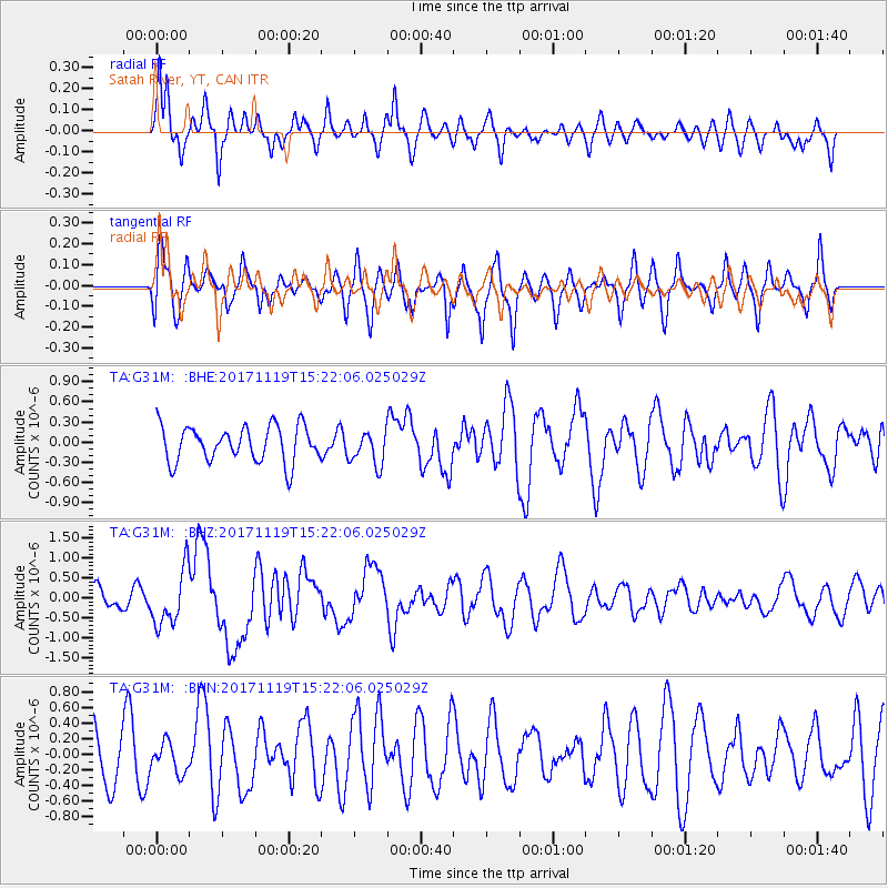
G31M Satah River, YT, CAN - Earthquake Result Viewer
*The percent match for this event was below the threshold and hence no stack was calculated.
| Earthquake location: |
Loyalty Islands |
| Earthquake latitude/longitude: |
-21.5/168.5 |
| Earthquake time(UTC): |
2017/11/19 (323) 15:09:03 GMT |
| Earthquake Depth: |
14 km |
| Earthquake Magnitude: |
6.6 mww |
| Earthquake Catalog/Contributor: |
NEIC PDE/us |
|
| Network: |
TA USArray Transportable Network (new EarthScope stations) |
| Station: |
G31M Satah River, YT, CAN |
| Lat/Lon: |
66.92 N/134.27 W |
| Elevation: |
61 m |
|
| Distance: |
97.8 deg |
| Az: |
19.537 deg |
| Baz: |
232.179 deg |
| Ray Param: |
$rayparam |
*The percent match for this event was below the threshold and hence was not used in the summary stack. |
|
| Radial Match: |
55.53644 % |
| Radial Bump: |
392 |
| Transverse Match: |
64.06047 % |
| Transverse Bump: |
400 |
| SOD ConfigId: |
13570011 |
| Insert Time: |
2019-04-29 06:56:10.281 +0000 |
| GWidth: |
2.5 |
| Max Bumps: |
400 |
| Tol: |
0.001 |
|
Signal To Noise
| Channel | StoN | STA | LTA |
| TA:G31M: :BHZ:20171119T15:22:06.025029Z | 2.6247263 | 6.964869E-7 | 2.65356E-7 |
| TA:G31M: :BHN:20171119T15:22:06.025029Z | 0.47090417 | 1.8919312E-7 | 4.0176565E-7 |
| TA:G31M: :BHE:20171119T15:22:06.025029Z | 0.96004575 | 2.5396045E-7 | 2.6452955E-7 |
| Arrivals |
| Ps | |
| PpPs | |
| PsPs/PpSs | |


