You are here: Home > Network List > TA - USArray Transportable Network (new EarthScope stations) Stations List
> Station L20K Farewell, AK, USA > Earthquake Result Viewer
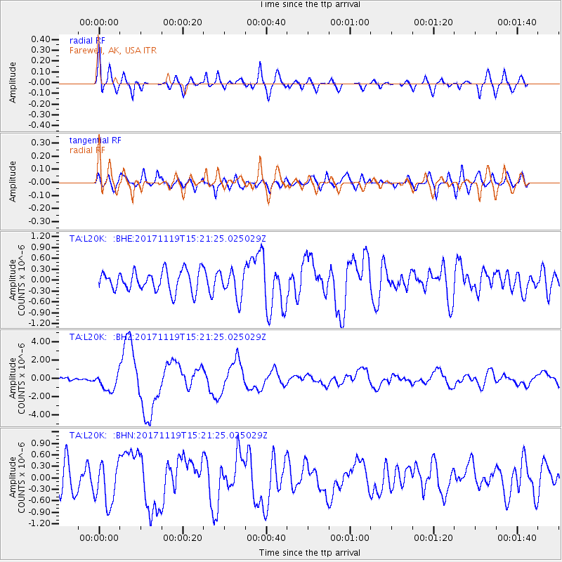
L20K Farewell, AK, USA - Earthquake Result Viewer
*The percent match for this event was below the threshold and hence no stack was calculated.
| Earthquake location: |
Loyalty Islands |
| Earthquake latitude/longitude: |
-21.5/168.5 |
| Earthquake time(UTC): |
2017/11/19 (323) 15:09:03 GMT |
| Earthquake Depth: |
14 km |
| Earthquake Magnitude: |
6.6 mww |
| Earthquake Catalog/Contributor: |
NEIC PDE/us |
|
| Network: |
TA USArray Transportable Network (new EarthScope stations) |
| Station: |
L20K Farewell, AK, USA |
| Lat/Lon: |
62.48 N/153.88 W |
| Elevation: |
673 m |
|
| Distance: |
88.9 deg |
| Az: |
16.46 deg |
| Baz: |
214.608 deg |
| Ray Param: |
$rayparam |
*The percent match for this event was below the threshold and hence was not used in the summary stack. |
|
| Radial Match: |
78.36301 % |
| Radial Bump: |
400 |
| Transverse Match: |
46.944664 % |
| Transverse Bump: |
400 |
| SOD ConfigId: |
13570011 |
| Insert Time: |
2019-04-29 06:56:32.448 +0000 |
| GWidth: |
2.5 |
| Max Bumps: |
400 |
| Tol: |
0.001 |
|
Signal To Noise
| Channel | StoN | STA | LTA |
| TA:L20K: :BHZ:20171119T15:21:25.025029Z | 3.8322117 | 9.744156E-7 | 2.5426974E-7 |
| TA:L20K: :BHN:20171119T15:21:25.025029Z | 1.4692141 | 5.428636E-7 | 3.6949248E-7 |
| TA:L20K: :BHE:20171119T15:21:25.025029Z | 1.3866066 | 3.8892702E-7 | 2.8048836E-7 |
| Arrivals |
| Ps | |
| PpPs | |
| PsPs/PpSs | |


