You are here: Home > Network List > CI - Caltech Regional Seismic Network Stations List
> Station GRA Grapevine Ranger Station, Death Valley, CA, USA > Earthquake Result Viewer
GRA Grapevine Ranger Station, Death Valley, CA, USA - Earthquake Result Viewer
| Earthquake location: |
W. Caroline Islands, Micronesia |
| Earthquake latitude/longitude: |
10.9/140.8 |
| Earthquake time(UTC): |
2005/01/16 (016) 20:17:52 GMT |
| Earthquake Depth: |
25 km |
| Earthquake Magnitude: |
6.3 MB, 6.7 MS, 6.6 MW, 6.6 MW |
| Earthquake Catalog/Contributor: |
WHDF/NEIC |
|
| Network: |
CI Caltech Regional Seismic Network |
| Station: |
GRA Grapevine Ranger Station, Death Valley, CA, USA |
| Lat/Lon: |
37.00 N/117.37 W |
| Elevation: |
689 m |
|
| Distance: |
92.7 deg |
| Az: |
51.685 deg |
| Baz: |
285.75 deg |
| Ray Param: |
0.041392375 |
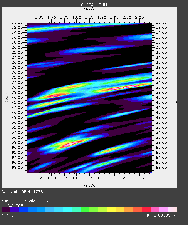
| Estimated Moho Depth: |
35.75 km |
| Estimated Crust Vp/Vs: |
1.99 |
| Assumed Crust Vp: |
6.279 km/s |
| Estimated Crust Vs: |
3.163 km/s |
| Estimated Crust Poisson's Ratio: |
0.33 |
|
| Radial Match: |
85.644775 % |
| Radial Bump: |
400 |
| Transverse Match: |
84.45805 % |
| Transverse Bump: |
400 |
| SOD ConfigId: |
5233 |
| Insert Time: |
2010-02-26 01:39:29.835 +0000 |
| GWidth: |
2.5 |
| Max Bumps: |
400 |
| Tol: |
0.001 |
|

Signal To Noise
| Channel | StoN | STA | LTA |
| CI:GRA: :BHN:20050116T20:30:31.194021Z | 2.452557 | 4.9004734E-7 | 1.9981077E-7 |
| CI:GRA: :BHE:20050116T20:30:31.194021Z | 2.1926508 | 7.10929E-7 | 3.2423264E-7 |
| CI:GRA: :BHZ:20050116T20:30:31.194021Z | 5.3059196 | 1.2097232E-6 | 2.2799503E-7 |
| Arrivals |
| Ps | 5.7 SECOND |
| PpPs | 17 SECOND |
| PsPs/PpSs | 22 SECOND |


