You are here: Home > Network List > TA - USArray Transportable Network (new EarthScope stations) Stations List
> Station Q17K Contact Creek, Katmai, AK, USA > Earthquake Result Viewer
Q17K Contact Creek, Katmai, AK, USA - Earthquake Result Viewer
| Earthquake location: |
Loyalty Islands |
| Earthquake latitude/longitude: |
-21.5/168.5 |
| Earthquake time(UTC): |
2017/11/19 (323) 15:09:03 GMT |
| Earthquake Depth: |
14 km |
| Earthquake Magnitude: |
6.6 mww |
| Earthquake Catalog/Contributor: |
NEIC PDE/us |
|
| Network: |
TA USArray Transportable Network (new EarthScope stations) |
| Station: |
Q17K Contact Creek, Katmai, AK, USA |
| Lat/Lon: |
58.26 N/155.89 W |
| Elevation: |
1165 m |
|
| Distance: |
84.8 deg |
| Az: |
17.984 deg |
| Baz: |
212.95 deg |
| Ray Param: |
0.045221996 |
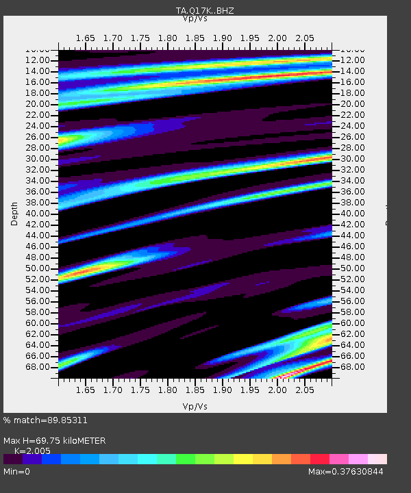
| Estimated Moho Depth: |
69.75 km |
| Estimated Crust Vp/Vs: |
2.01 |
| Assumed Crust Vp: |
6.438 km/s |
| Estimated Crust Vs: |
3.211 km/s |
| Estimated Crust Poisson's Ratio: |
0.33 |
|
| Radial Match: |
89.85311 % |
| Radial Bump: |
400 |
| Transverse Match: |
67.145226 % |
| Transverse Bump: |
400 |
| SOD ConfigId: |
13570011 |
| Insert Time: |
2019-04-29 06:57:04.319 +0000 |
| GWidth: |
2.5 |
| Max Bumps: |
400 |
| Tol: |
0.001 |
|
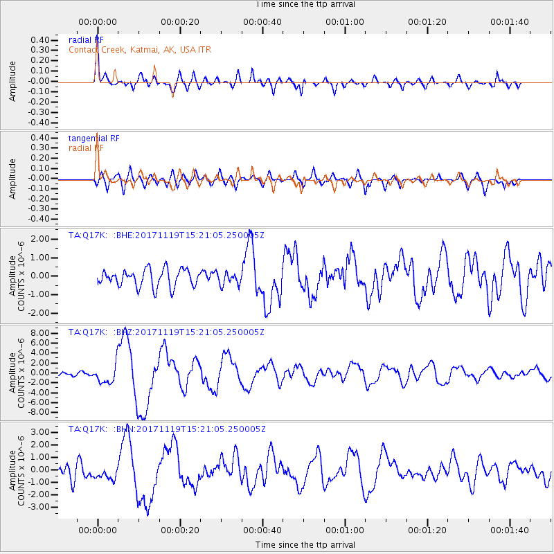
Signal To Noise
| Channel | StoN | STA | LTA |
| TA:Q17K: :BHZ:20171119T15:21:05.250005Z | 5.412334 | 2.0761834E-6 | 3.836022E-7 |
| TA:Q17K: :BHN:20171119T15:21:05.250005Z | 1.2360519 | 5.2548233E-7 | 4.2512966E-7 |
| TA:Q17K: :BHE:20171119T15:21:05.250005Z | 0.6832079 | 3.1730826E-7 | 4.6443876E-7 |
| Arrivals |
| Ps | 11 SECOND |
| PpPs | 32 SECOND |
| PsPs/PpSs | 43 SECOND |


