You are here: Home > Network List > TA - USArray Transportable Network (new EarthScope stations) Stations List
> Station Q20K Shuyak Island, AK, USA > Earthquake Result Viewer
Q20K Shuyak Island, AK, USA - Earthquake Result Viewer
| Earthquake location: |
Loyalty Islands |
| Earthquake latitude/longitude: |
-21.5/168.5 |
| Earthquake time(UTC): |
2017/11/19 (323) 15:09:03 GMT |
| Earthquake Depth: |
14 km |
| Earthquake Magnitude: |
6.6 mww |
| Earthquake Catalog/Contributor: |
NEIC PDE/us |
|
| Network: |
TA USArray Transportable Network (new EarthScope stations) |
| Station: |
Q20K Shuyak Island, AK, USA |
| Lat/Lon: |
58.61 N/152.39 W |
| Elevation: |
180 m |
|
| Distance: |
86.1 deg |
| Az: |
19.305 deg |
| Baz: |
216.025 deg |
| Ray Param: |
0.04427264 |
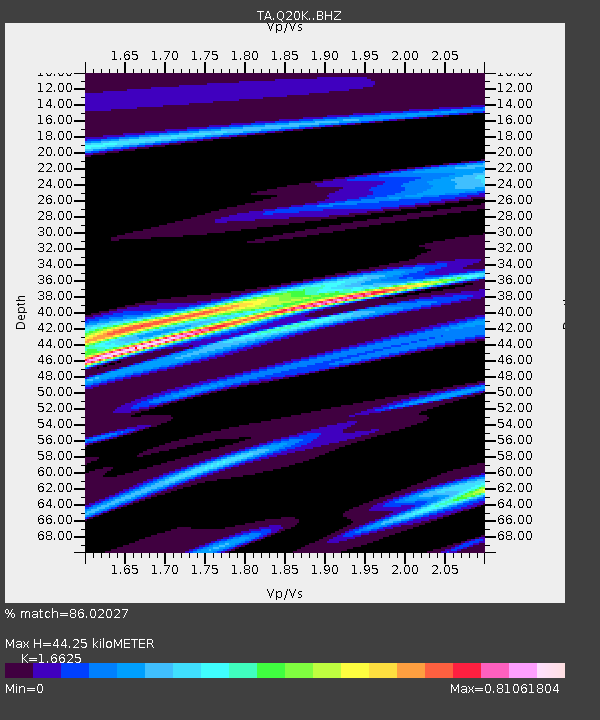
| Estimated Moho Depth: |
44.25 km |
| Estimated Crust Vp/Vs: |
1.66 |
| Assumed Crust Vp: |
5.989 km/s |
| Estimated Crust Vs: |
3.602 km/s |
| Estimated Crust Poisson's Ratio: |
0.22 |
|
| Radial Match: |
86.02027 % |
| Radial Bump: |
400 |
| Transverse Match: |
62.47676 % |
| Transverse Bump: |
400 |
| SOD ConfigId: |
13570011 |
| Insert Time: |
2019-04-29 06:57:05.860 +0000 |
| GWidth: |
2.5 |
| Max Bumps: |
400 |
| Tol: |
0.001 |
|

Signal To Noise
| Channel | StoN | STA | LTA |
| TA:Q20K: :BHZ:20171119T15:21:11.84998Z | 4.401861 | 1.4977528E-6 | 3.4025445E-7 |
| TA:Q20K: :BHN:20171119T15:21:11.84998Z | 1.6093227 | 6.479718E-7 | 4.0263635E-7 |
| TA:Q20K: :BHE:20171119T15:21:11.84998Z | 1.0164762 | 4.085098E-7 | 4.0188826E-7 |
| Arrivals |
| Ps | 5.0 SECOND |
| PpPs | 19 SECOND |
| PsPs/PpSs | 24 SECOND |


