You are here: Home > Network List > TA - USArray Transportable Network (new EarthScope stations) Stations List
> Station B13A Whitefish, MT, USA > Earthquake Result Viewer
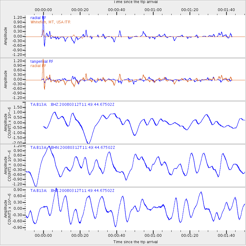
B13A Whitefish, MT, USA - Earthquake Result Viewer
*The percent match for this event was below the threshold and hence no stack was calculated.
| Earthquake location: |
Vanuatu Islands |
| Earthquake latitude/longitude: |
-16.5/167.2 |
| Earthquake time(UTC): |
2008/03/12 (072) 11:36:55 GMT |
| Earthquake Depth: |
10 km |
| Earthquake Magnitude: |
5.6 MB, 6.3 MW |
| Earthquake Catalog/Contributor: |
WHDF/NEIC |
|
| Network: |
TA USArray Transportable Network (new EarthScope stations) |
| Station: |
B13A Whitefish, MT, USA |
| Lat/Lon: |
48.37 N/114.47 W |
| Elevation: |
933 m |
|
| Distance: |
94.6 deg |
| Az: |
40.933 deg |
| Baz: |
250.514 deg |
| Ray Param: |
$rayparam |
*The percent match for this event was below the threshold and hence was not used in the summary stack. |
|
| Radial Match: |
64.40633 % |
| Radial Bump: |
400 |
| Transverse Match: |
53.73043 % |
| Transverse Bump: |
400 |
| SOD ConfigId: |
2504 |
| Insert Time: |
2010-03-06 06:51:48.258 +0000 |
| GWidth: |
2.5 |
| Max Bumps: |
400 |
| Tol: |
0.001 |
|
Signal To Noise
| Channel | StoN | STA | LTA |
| TA:B13A: :BHN:20080312T11:49:44.67502Z | 2.4787903 | 9.1240577E-7 | 3.680851E-7 |
| TA:B13A: :BHE:20080312T11:49:44.67502Z | 0.50077254 | 1.5480457E-7 | 3.091315E-7 |
| TA:B13A: :BHZ:20080312T11:49:44.67502Z | 0.64124984 | 4.8728015E-7 | 7.598913E-7 |
| Arrivals |
| Ps | |
| PpPs | |
| PsPs/PpSs | |


