You are here: Home > Network List > TA - USArray Transportable Network (new EarthScope stations) Stations List
> Station B13A Whitefish, MT, USA > Earthquake Result Viewer
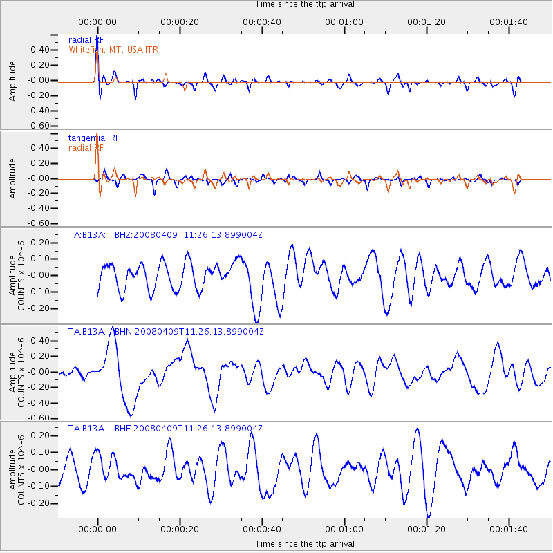
B13A Whitefish, MT, USA - Earthquake Result Viewer
*The percent match for this event was below the threshold and hence no stack was calculated.
| Earthquake location: |
Loyalty Islands |
| Earthquake latitude/longitude: |
-20.2/168.9 |
| Earthquake time(UTC): |
2008/04/09 (100) 11:13:17 GMT |
| Earthquake Depth: |
13 km |
| Earthquake Magnitude: |
5.6 MB, 6.3 MS, 6.4 MW, 6.3 MW |
| Earthquake Catalog/Contributor: |
WHDF/NEIC |
|
| Network: |
TA USArray Transportable Network (new EarthScope stations) |
| Station: |
B13A Whitefish, MT, USA |
| Lat/Lon: |
48.37 N/114.47 W |
| Elevation: |
933 m |
|
| Distance: |
96.4 deg |
| Az: |
40.756 deg |
| Baz: |
246.894 deg |
| Ray Param: |
$rayparam |
*The percent match for this event was below the threshold and hence was not used in the summary stack. |
|
| Radial Match: |
56.066013 % |
| Radial Bump: |
362 |
| Transverse Match: |
54.729053 % |
| Transverse Bump: |
304 |
| SOD ConfigId: |
2504 |
| Insert Time: |
2010-03-06 06:51:53.099 +0000 |
| GWidth: |
2.5 |
| Max Bumps: |
400 |
| Tol: |
0.001 |
|
Signal To Noise
| Channel | StoN | STA | LTA |
| TA:B13A: :BHN:20080409T11:26:13.899004Z | 4.589617 | 3.2318485E-7 | 7.041652E-8 |
| TA:B13A: :BHE:20080409T11:26:13.899004Z | 1.0365161 | 7.745277E-8 | 7.4724134E-8 |
| TA:B13A: :BHZ:20080409T11:26:13.899004Z | 0.92793435 | 7.341089E-8 | 7.9112155E-8 |
| Arrivals |
| Ps | |
| PpPs | |
| PsPs/PpSs | |


