You are here: Home > Network List > AZ - ANZA Regional Network Stations List
> Station SMER AZ.SMER > Earthquake Result Viewer
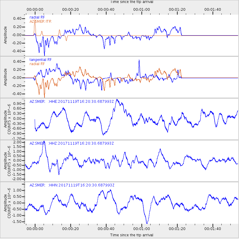
SMER AZ.SMER - Earthquake Result Viewer
*The percent match for this event was below the threshold and hence no stack was calculated.
| Earthquake location: |
Loyalty Islands |
| Earthquake latitude/longitude: |
-21.2/168.5 |
| Earthquake time(UTC): |
2017/11/19 (323) 16:08:06 GMT |
| Earthquake Depth: |
10 km |
| Earthquake Magnitude: |
5.9 Mww |
| Earthquake Catalog/Contributor: |
NEIC PDE/us |
|
| Network: |
AZ ANZA Regional Network |
| Station: |
SMER AZ.SMER |
| Lat/Lon: |
33.46 N/117.17 W |
| Elevation: |
355 m |
|
| Distance: |
89.2 deg |
| Az: |
53.591 deg |
| Baz: |
243.934 deg |
| Ray Param: |
$rayparam |
*The percent match for this event was below the threshold and hence was not used in the summary stack. |
|
| Radial Match: |
72.70454 % |
| Radial Bump: |
400 |
| Transverse Match: |
61.66064 % |
| Transverse Bump: |
400 |
| SOD ConfigId: |
13570011 |
| Insert Time: |
2019-04-29 06:59:23.245 +0000 |
| GWidth: |
2.5 |
| Max Bumps: |
400 |
| Tol: |
0.001 |
|
Signal To Noise
| Channel | StoN | STA | LTA |
| AZ:SMER: :HHZ:20171119T16:20:30.687993Z | 1.304956 | 7.1432555E-7 | 5.473944E-7 |
| AZ:SMER: :HHN:20171119T16:20:30.687993Z | 1.9762689 | 6.1615145E-7 | 3.1177512E-7 |
| AZ:SMER: :HHE:20171119T16:20:30.687993Z | 0.61309975 | 2.545105E-7 | 4.1512087E-7 |
| Arrivals |
| Ps | |
| PpPs | |
| PsPs/PpSs | |


