You are here: Home > Network List > TA - USArray Transportable Network (new EarthScope stations) Stations List
> Station B13A Whitefish, MT, USA > Earthquake Result Viewer
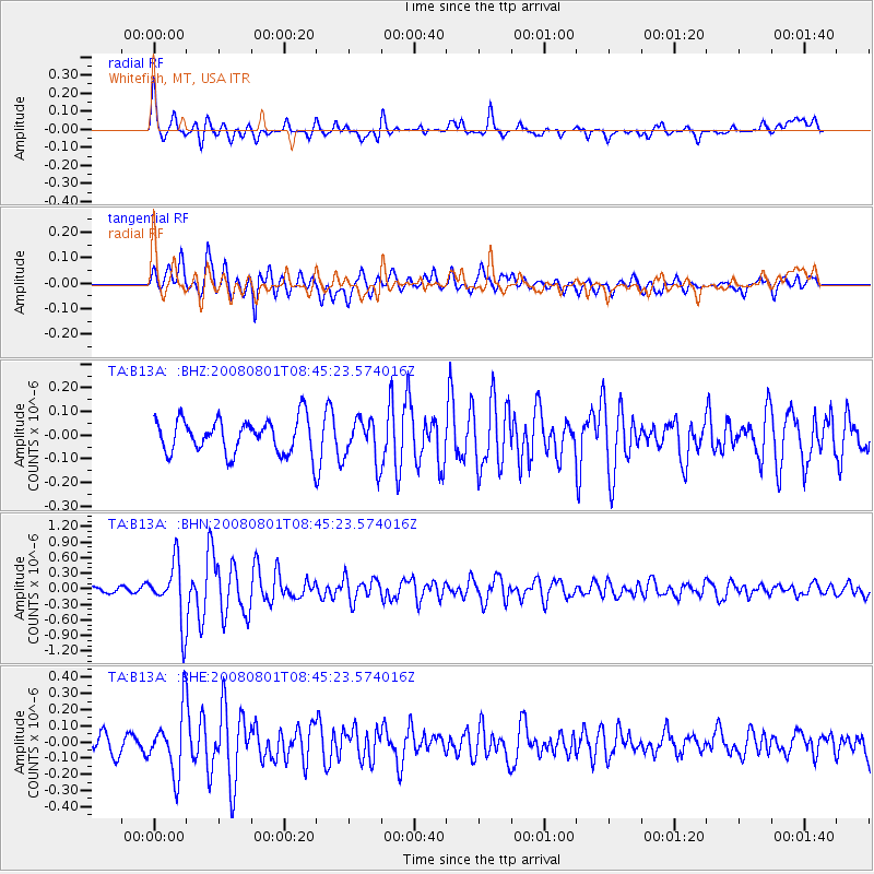
B13A Whitefish, MT, USA - Earthquake Result Viewer
*The percent match for this event was below the threshold and hence no stack was calculated.
| Earthquake location: |
Sichuan, China |
| Earthquake latitude/longitude: |
32.0/104.7 |
| Earthquake time(UTC): |
2008/08/01 (214) 08:32:43 GMT |
| Earthquake Depth: |
7.0 km |
| Earthquake Magnitude: |
5.9 MB, 5.6 MS, 5.7 MW, 5.7 MW |
| Earthquake Catalog/Contributor: |
WHDF/NEIC |
|
| Network: |
TA USArray Transportable Network (new EarthScope stations) |
| Station: |
B13A Whitefish, MT, USA |
| Lat/Lon: |
48.37 N/114.47 W |
| Elevation: |
933 m |
|
| Distance: |
92.6 deg |
| Az: |
24.945 deg |
| Baz: |
327.505 deg |
| Ray Param: |
$rayparam |
*The percent match for this event was below the threshold and hence was not used in the summary stack. |
|
| Radial Match: |
72.74196 % |
| Radial Bump: |
400 |
| Transverse Match: |
67.92262 % |
| Transverse Bump: |
400 |
| SOD ConfigId: |
2504 |
| Insert Time: |
2010-03-06 06:52:11.945 +0000 |
| GWidth: |
2.5 |
| Max Bumps: |
400 |
| Tol: |
0.001 |
|
Signal To Noise
| Channel | StoN | STA | LTA |
| TA:B13A: :BHN:20080801T08:45:23.574016Z | 7.1432805 | 5.639706E-7 | 7.895121E-8 |
| TA:B13A: :BHE:20080801T08:45:23.574016Z | 3.0700774 | 1.8911962E-7 | 6.160093E-8 |
| TA:B13A: :BHZ:20080801T08:45:23.574016Z | 1.2486398 | 9.0191385E-8 | 7.223171E-8 |
| Arrivals |
| Ps | |
| PpPs | |
| PsPs/PpSs | |


