You are here: Home > Network List > TA - USArray Transportable Network (new EarthScope stations) Stations List
> Station B13A Whitefish, MT, USA > Earthquake Result Viewer
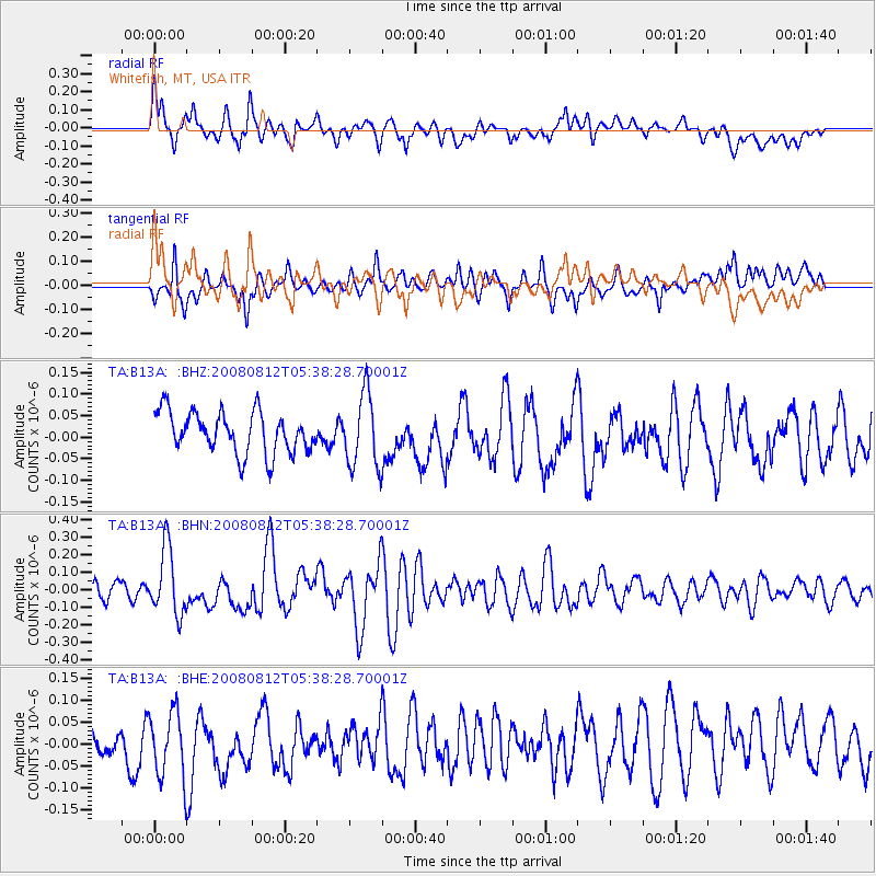
B13A Whitefish, MT, USA - Earthquake Result Viewer
*The percent match for this event was below the threshold and hence no stack was calculated.
| Earthquake location: |
Santa Cruz Islands |
| Earthquake latitude/longitude: |
-11.4/166.2 |
| Earthquake time(UTC): |
2008/08/12 (225) 05:25:57 GMT |
| Earthquake Depth: |
38 km |
| Earthquake Magnitude: |
5.9 MW, 5.4 MS, 5.2 MB, 5.8 MW |
| Earthquake Catalog/Contributor: |
WHDF/NEIC |
|
| Network: |
TA USArray Transportable Network (new EarthScope stations) |
| Station: |
B13A Whitefish, MT, USA |
| Lat/Lon: |
48.37 N/114.47 W |
| Elevation: |
933 m |
|
| Distance: |
91.5 deg |
| Az: |
40.949 deg |
| Baz: |
254.513 deg |
| Ray Param: |
$rayparam |
*The percent match for this event was below the threshold and hence was not used in the summary stack. |
|
| Radial Match: |
59.74844 % |
| Radial Bump: |
400 |
| Transverse Match: |
56.239025 % |
| Transverse Bump: |
400 |
| SOD ConfigId: |
2504 |
| Insert Time: |
2010-03-06 06:52:13.893 +0000 |
| GWidth: |
2.5 |
| Max Bumps: |
400 |
| Tol: |
0.001 |
|
Signal To Noise
| Channel | StoN | STA | LTA |
| TA:B13A: :BHN:20080812T05:38:28.70001Z | 3.6853375 | 1.8986712E-7 | 5.1519603E-8 |
| TA:B13A: :BHE:20080812T05:38:28.70001Z | 1.6570933 | 7.665847E-8 | 4.626081E-8 |
| TA:B13A: :BHZ:20080812T05:38:28.70001Z | 1.797875 | 8.6260236E-8 | 4.7978997E-8 |
| Arrivals |
| Ps | |
| PpPs | |
| PsPs/PpSs | |


