You are here: Home > Network List > UU - University of Utah Regional Network Stations List
> Station KNB Kanab, UT, USA > Earthquake Result Viewer
KNB Kanab, UT, USA - Earthquake Result Viewer
| Earthquake location: |
Vanuatu Islands |
| Earthquake latitude/longitude: |
-14.0/166.6 |
| Earthquake time(UTC): |
2016/04/07 (098) 03:32:53 GMT |
| Earthquake Depth: |
27 km |
| Earthquake Magnitude: |
6.7 MWW, 6.5 MWB, 6.9 MI |
| Earthquake Catalog/Contributor: |
NEIC PDE/NEIC COMCAT |
|
| Network: |
UU University of Utah Regional Network |
| Station: |
KNB Kanab, UT, USA |
| Lat/Lon: |
37.02 N/112.82 W |
| Elevation: |
1715 m |
|
| Distance: |
91.0 deg |
| Az: |
52.165 deg |
| Baz: |
253.301 deg |
| Ray Param: |
0.041631285 |
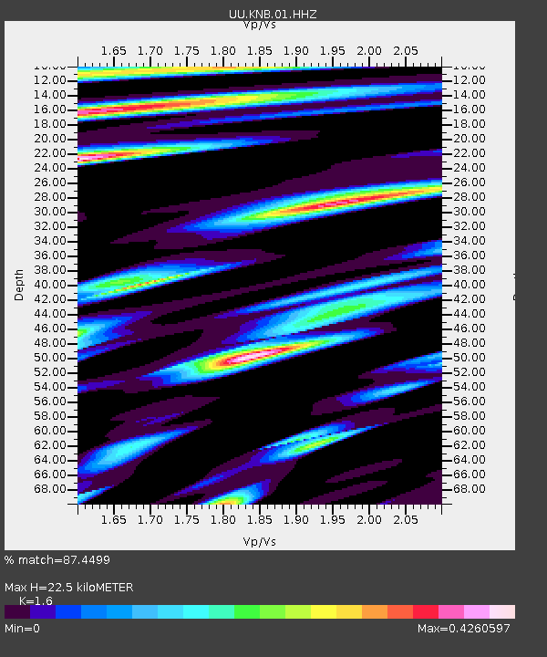
| Estimated Moho Depth: |
22.5 km |
| Estimated Crust Vp/Vs: |
1.60 |
| Assumed Crust Vp: |
6.194 km/s |
| Estimated Crust Vs: |
3.871 km/s |
| Estimated Crust Poisson's Ratio: |
0.18 |
|
| Radial Match: |
87.4499 % |
| Radial Bump: |
400 |
| Transverse Match: |
66.23016 % |
| Transverse Bump: |
400 |
| SOD ConfigId: |
1475611 |
| Insert Time: |
2016-04-21 03:38:10.713 +0000 |
| GWidth: |
2.5 |
| Max Bumps: |
400 |
| Tol: |
0.001 |
|

Signal To Noise
| Channel | StoN | STA | LTA |
| UU:KNB:01:HHZ:20160407T03:45:23.940024Z | 9.737649 | 3.2972608E-8 | 3.3860952E-9 |
| UU:KNB:01:HHN:20160407T03:45:23.940024Z | 1.8342342 | 5.3686957E-9 | 2.9269411E-9 |
| UU:KNB:01:HHE:20160407T03:45:23.940024Z | 4.5058703 | 1.208388E-8 | 2.6818079E-9 |
| Arrivals |
| Ps | 2.2 SECOND |
| PpPs | 9.2 SECOND |
| PsPs/PpSs | 11 SECOND |


