You are here: Home > Network List > TA - USArray Transportable Network (new EarthScope stations) Stations List
> Station B13A Whitefish, MT, USA > Earthquake Result Viewer
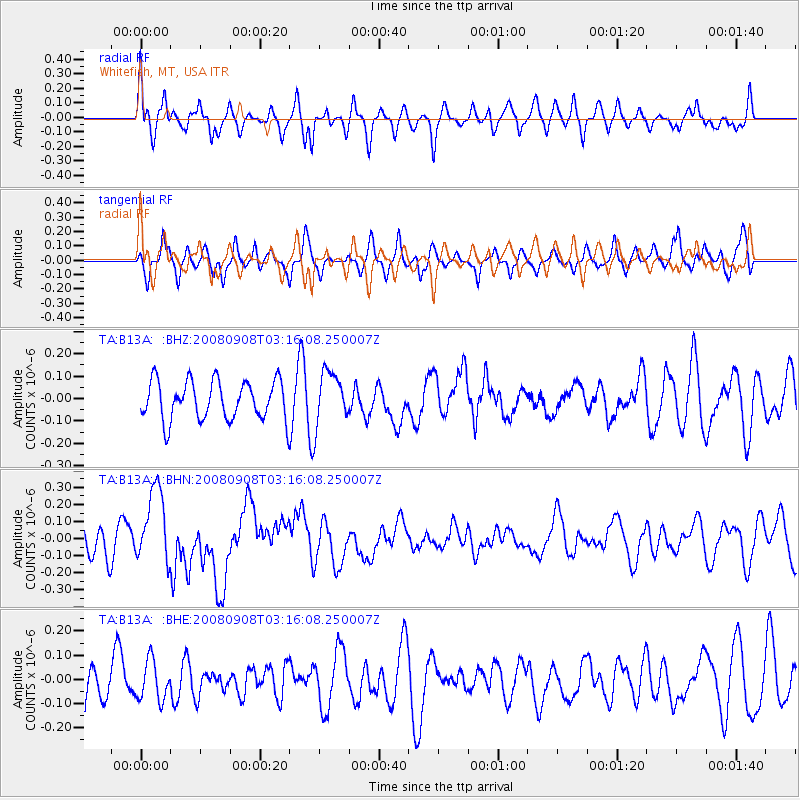
B13A Whitefish, MT, USA - Earthquake Result Viewer
*The percent match for this event was below the threshold and hence no stack was calculated.
| Earthquake location: |
Vanuatu Islands |
| Earthquake latitude/longitude: |
-20.0/169.1 |
| Earthquake time(UTC): |
2008/09/08 (252) 03:03:15 GMT |
| Earthquake Depth: |
36 km |
| Earthquake Magnitude: |
6.0 MB, 5.8 MS, 6.2 MW, 6.2 MW |
| Earthquake Catalog/Contributor: |
WHDF/NEIC |
|
| Network: |
TA USArray Transportable Network (new EarthScope stations) |
| Station: |
B13A Whitefish, MT, USA |
| Lat/Lon: |
48.37 N/114.47 W |
| Elevation: |
933 m |
|
| Distance: |
96.1 deg |
| Az: |
40.676 deg |
| Baz: |
246.855 deg |
| Ray Param: |
$rayparam |
*The percent match for this event was below the threshold and hence was not used in the summary stack. |
|
| Radial Match: |
60.441257 % |
| Radial Bump: |
400 |
| Transverse Match: |
50.887978 % |
| Transverse Bump: |
382 |
| SOD ConfigId: |
2560 |
| Insert Time: |
2010-03-06 06:52:28.533 +0000 |
| GWidth: |
2.5 |
| Max Bumps: |
400 |
| Tol: |
0.001 |
|
Signal To Noise
| Channel | StoN | STA | LTA |
| TA:B13A: :BHN:20080908T03:16:08.250007Z | 2.3317015 | 2.1854365E-7 | 9.372712E-8 |
| TA:B13A: :BHE:20080908T03:16:08.250007Z | 0.72724086 | 8.19803E-8 | 1.1272785E-7 |
| TA:B13A: :BHZ:20080908T03:16:08.250007Z | 1.3502234 | 1.18053265E-7 | 8.743239E-8 |
| Arrivals |
| Ps | |
| PpPs | |
| PsPs/PpSs | |


