You are here: Home > Network List > TA - USArray Transportable Network (new EarthScope stations) Stations List
> Station B13A Whitefish, MT, USA > Earthquake Result Viewer
B13A Whitefish, MT, USA - Earthquake Result Viewer
*The percent match for this event was below the threshold and hence no stack was calculated.
| Earthquake location: |
Komandorskiye Ostrova Region |
| Earthquake latitude/longitude: |
56.3/164.1 |
| Earthquake time(UTC): |
2008/09/12 (256) 23:07:50 GMT |
| Earthquake Depth: |
9.3 km |
| Earthquake Magnitude: |
5.5 MB, 5.7 MS, 5.9 MW, 5.9 MW |
| Earthquake Catalog/Contributor: |
WHDF/NEIC |
|
| Network: |
TA USArray Transportable Network (new EarthScope stations) |
| Station: |
B13A Whitefish, MT, USA |
| Lat/Lon: |
48.37 N/114.47 W |
| Elevation: |
933 m |
|
| Distance: |
47.6 deg |
| Az: |
63.204 deg |
| Baz: |
311.744 deg |
| Ray Param: |
$rayparam |
*The percent match for this event was below the threshold and hence was not used in the summary stack. |
|
| Radial Match: |
62.652225 % |
| Radial Bump: |
400 |
| Transverse Match: |
48.82799 % |
| Transverse Bump: |
400 |
| SOD ConfigId: |
2560 |
| Insert Time: |
2010-03-06 06:52:31.795 +0000 |
| GWidth: |
2.5 |
| Max Bumps: |
400 |
| Tol: |
0.001 |
|
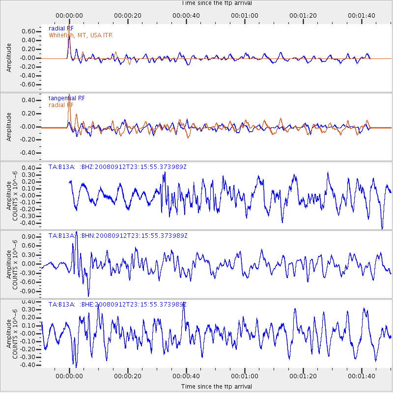
Signal To Noise
| Channel | StoN | STA | LTA |
| TA:B13A: :BHN:20080912T23:15:55.373989Z | 4.038675 | 4.6130776E-7 | 1.1422256E-7 |
| TA:B13A: :BHE:20080912T23:15:55.373989Z | 1.8682697 | 1.9877544E-7 | 1.06395476E-7 |
| TA:B13A: :BHZ:20080912T23:15:55.373989Z | 1.5593201 | 1.5684934E-7 | 1.0058829E-7 |
| Arrivals |
| Ps | |
| PpPs | |
| PsPs/PpSs | |


