You are here: Home > Network List > TA - USArray Transportable Network (new EarthScope stations) Stations List
> Station B13A Whitefish, MT, USA > Earthquake Result Viewer
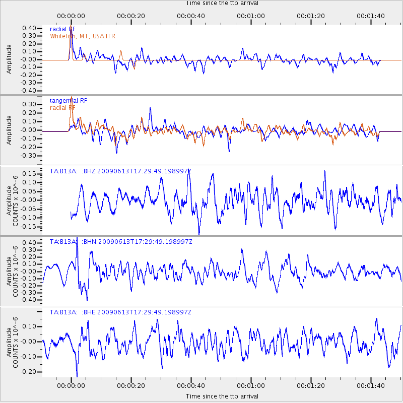
B13A Whitefish, MT, USA - Earthquake Result Viewer
*The percent match for this event was below the threshold and hence no stack was calculated.
| Earthquake location: |
Eastern Kazakhstan |
| Earthquake latitude/longitude: |
44.7/78.9 |
| Earthquake time(UTC): |
2009/06/13 (164) 17:17:38 GMT |
| Earthquake Depth: |
14 km |
| Earthquake Magnitude: |
5.8 MB, 5.1 MS, 5.4 MW, 5.4 MW |
| Earthquake Catalog/Contributor: |
WHDF/NEIC |
|
| Network: |
TA USArray Transportable Network (new EarthScope stations) |
| Station: |
B13A Whitefish, MT, USA |
| Lat/Lon: |
48.37 N/114.47 W |
| Elevation: |
933 m |
|
| Distance: |
86.6 deg |
| Az: |
8.86 deg |
| Baz: |
350.522 deg |
| Ray Param: |
$rayparam |
*The percent match for this event was below the threshold and hence was not used in the summary stack. |
|
| Radial Match: |
52.95004 % |
| Radial Bump: |
400 |
| Transverse Match: |
52.306667 % |
| Transverse Bump: |
400 |
| SOD ConfigId: |
2648 |
| Insert Time: |
2010-03-06 06:52:49.219 +0000 |
| GWidth: |
2.5 |
| Max Bumps: |
400 |
| Tol: |
0.001 |
|
Signal To Noise
| Channel | StoN | STA | LTA |
| TA:B13A: :BHN:20090613T17:29:49.198997Z | 3.012405 | 1.9907395E-7 | 6.608472E-8 |
| TA:B13A: :BHE:20090613T17:29:49.198997Z | 1.7348936 | 8.4906155E-8 | 4.8940272E-8 |
| TA:B13A: :BHZ:20090613T17:29:49.198997Z | 1.6791115 | 7.941438E-8 | 4.7295476E-8 |
| Arrivals |
| Ps | |
| PpPs | |
| PsPs/PpSs | |


