You are here: Home > Network List > TA - USArray Transportable Network (new EarthScope stations) Stations List
> Station B13A Whitefish, MT, USA > Earthquake Result Viewer
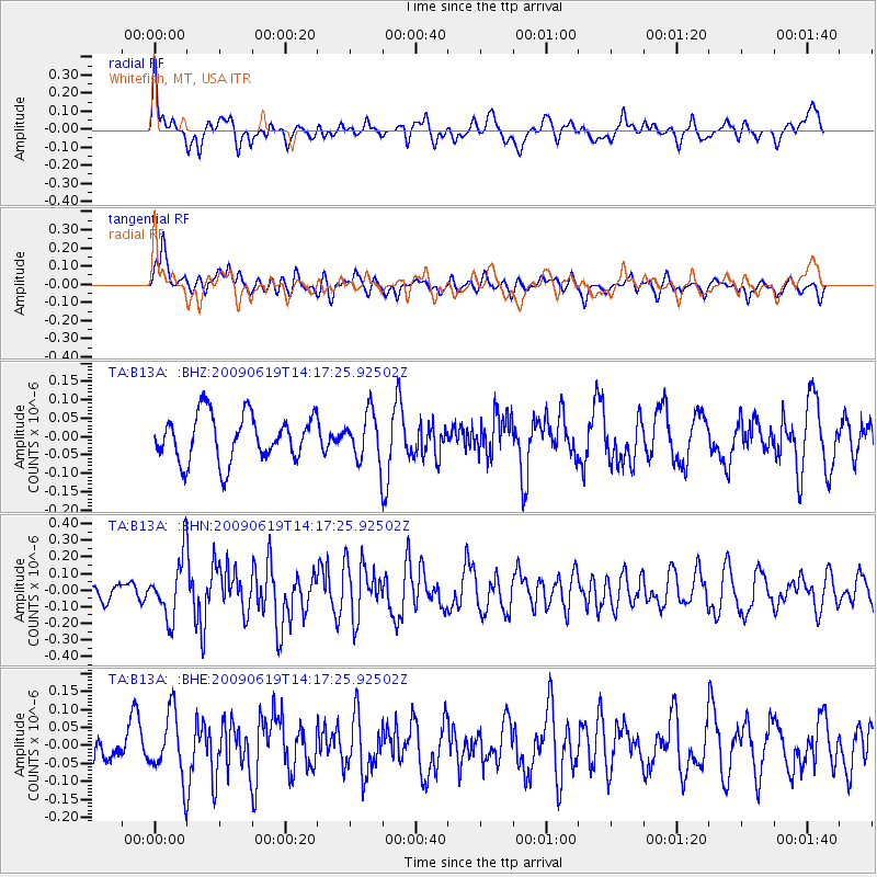
B13A Whitefish, MT, USA - Earthquake Result Viewer
*The percent match for this event was below the threshold and hence no stack was calculated.
| Earthquake location: |
Eastern Mediterranean Sea |
| Earthquake latitude/longitude: |
35.4/28.5 |
| Earthquake time(UTC): |
2009/06/19 (170) 14:04:59 GMT |
| Earthquake Depth: |
28 km |
| Earthquake Magnitude: |
5.6 MB, 5.6 MS, 5.8 MW, 5.8 MW |
| Earthquake Catalog/Contributor: |
WHDF/NEIC |
|
| Network: |
TA USArray Transportable Network (new EarthScope stations) |
| Station: |
B13A Whitefish, MT, USA |
| Lat/Lon: |
48.37 N/114.47 W |
| Elevation: |
933 m |
|
| Distance: |
90.3 deg |
| Az: |
336.296 deg |
| Baz: |
29.526 deg |
| Ray Param: |
$rayparam |
*The percent match for this event was below the threshold and hence was not used in the summary stack. |
|
| Radial Match: |
56.203655 % |
| Radial Bump: |
400 |
| Transverse Match: |
62.065598 % |
| Transverse Bump: |
400 |
| SOD ConfigId: |
2648 |
| Insert Time: |
2010-03-06 06:52:50.987 +0000 |
| GWidth: |
2.5 |
| Max Bumps: |
400 |
| Tol: |
0.001 |
|
Signal To Noise
| Channel | StoN | STA | LTA |
| TA:B13A: :BHN:20090619T14:17:25.92502Z | 3.3142924 | 1.814663E-7 | 5.4752654E-8 |
| TA:B13A: :BHE:20090619T14:17:25.92502Z | 1.8139179 | 9.0412115E-8 | 4.9843557E-8 |
| TA:B13A: :BHZ:20090619T14:17:25.92502Z | 1.0396249 | 6.470105E-8 | 6.223499E-8 |
| Arrivals |
| Ps | |
| PpPs | |
| PsPs/PpSs | |


