You are here: Home > Network List > TA - USArray Transportable Network (new EarthScope stations) Stations List
> Station B13A Whitefish, MT, USA > Earthquake Result Viewer
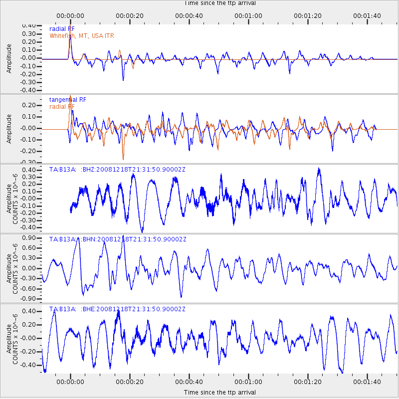
B13A Whitefish, MT, USA - Earthquake Result Viewer
*The percent match for this event was below the threshold and hence no stack was calculated.
| Earthquake location: |
Near Coast Of Central Chile |
| Earthquake latitude/longitude: |
-32.5/-71.7 |
| Earthquake time(UTC): |
2008/12/18 (353) 21:19:28 GMT |
| Earthquake Depth: |
18 km |
| Earthquake Magnitude: |
5.8 MB, 6.0 MS, 6.2 MW, 6.1 MW |
| Earthquake Catalog/Contributor: |
WHDF/NEIC |
|
| Network: |
TA USArray Transportable Network (new EarthScope stations) |
| Station: |
B13A Whitefish, MT, USA |
| Lat/Lon: |
48.37 N/114.47 W |
| Elevation: |
933 m |
|
| Distance: |
89.1 deg |
| Az: |
333.091 deg |
| Baz: |
144.981 deg |
| Ray Param: |
$rayparam |
*The percent match for this event was below the threshold and hence was not used in the summary stack. |
|
| Radial Match: |
58.565777 % |
| Radial Bump: |
359 |
| Transverse Match: |
63.60284 % |
| Transverse Bump: |
400 |
| SOD ConfigId: |
2658 |
| Insert Time: |
2010-03-06 06:52:54.653 +0000 |
| GWidth: |
2.5 |
| Max Bumps: |
400 |
| Tol: |
0.001 |
|
Signal To Noise
| Channel | StoN | STA | LTA |
| TA:B13A: :BHN:20081218T21:31:50.90002Z | 3.1160295 | 5.656663E-7 | 1.8153432E-7 |
| TA:B13A: :BHE:20081218T21:31:50.90002Z | 0.6022322 | 1.3567622E-7 | 2.2528886E-7 |
| TA:B13A: :BHZ:20081218T21:31:50.90002Z | 1.1082593 | 1.9453412E-7 | 1.7553123E-7 |
| Arrivals |
| Ps | |
| PpPs | |
| PsPs/PpSs | |


