You are here: Home > Network List > CI - Caltech Regional Seismic Network Stations List
> Station SWS Sam W. Stewart, Westmorland, CA, USA > Earthquake Result Viewer
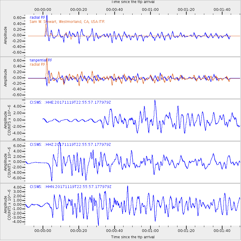
SWS Sam W. Stewart, Westmorland, CA, USA - Earthquake Result Viewer
*The percent match for this event was below the threshold and hence no stack was calculated.
| Earthquake location: |
Loyalty Islands |
| Earthquake latitude/longitude: |
-21.3/168.5 |
| Earthquake time(UTC): |
2017/11/19 (323) 22:43:29 GMT |
| Earthquake Depth: |
25 km |
| Earthquake Magnitude: |
7.3 Mi |
| Earthquake Catalog/Contributor: |
NEIC PDE/at |
|
| Network: |
CI Caltech Regional Seismic Network |
| Station: |
SWS Sam W. Stewart, Westmorland, CA, USA |
| Lat/Lon: |
32.94 N/115.80 W |
| Elevation: |
140 m |
|
| Distance: |
90.1 deg |
| Az: |
54.573 deg |
| Baz: |
244.64 deg |
| Ray Param: |
$rayparam |
*The percent match for this event was below the threshold and hence was not used in the summary stack. |
|
| Radial Match: |
92.45731 % |
| Radial Bump: |
400 |
| Transverse Match: |
81.74061 % |
| Transverse Bump: |
400 |
| SOD ConfigId: |
13570011 |
| Insert Time: |
2019-04-29 07:06:30.785 +0000 |
| GWidth: |
2.5 |
| Max Bumps: |
400 |
| Tol: |
0.001 |
|
Signal To Noise
| Channel | StoN | STA | LTA |
| CI:SWS: :HHZ:20171119T22:55:57.177979Z | 6.748181 | 1.6660056E-6 | 2.468822E-7 |
| CI:SWS: :HHN:20171119T22:55:57.177979Z | 1.1556344 | 3.7639518E-7 | 3.2570438E-7 |
| CI:SWS: :HHE:20171119T22:55:57.177979Z | 1.2112356 | 3.3965148E-7 | 2.8041734E-7 |
| Arrivals |
| Ps | |
| PpPs | |
| PsPs/PpSs | |


