You are here: Home > Network List > TA - USArray Transportable Network (new EarthScope stations) Stations List
> Station B13A Whitefish, MT, USA > Earthquake Result Viewer
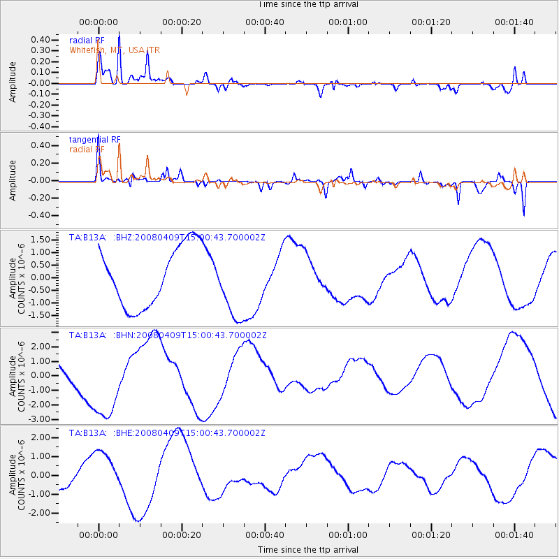
B13A Whitefish, MT, USA - Earthquake Result Viewer
*The percent match for this event was below the threshold and hence no stack was calculated.
| Earthquake location: |
Vanuatu Islands |
| Earthquake latitude/longitude: |
-20.0/168.9 |
| Earthquake time(UTC): |
2008/04/09 (100) 14:47:50 GMT |
| Earthquake Depth: |
35 km |
| Earthquake Magnitude: |
5.9 MB, 6.2 MS, 6.3 MW |
| Earthquake Catalog/Contributor: |
WHDF/NEIC |
|
| Network: |
TA USArray Transportable Network (new EarthScope stations) |
| Station: |
B13A Whitefish, MT, USA |
| Lat/Lon: |
48.37 N/114.47 W |
| Elevation: |
933 m |
|
| Distance: |
96.2 deg |
| Az: |
40.74 deg |
| Baz: |
247.001 deg |
| Ray Param: |
$rayparam |
*The percent match for this event was below the threshold and hence was not used in the summary stack. |
|
| Radial Match: |
79.13161 % |
| Radial Bump: |
400 |
| Transverse Match: |
56.881233 % |
| Transverse Bump: |
369 |
| SOD ConfigId: |
2504 |
| Insert Time: |
2010-03-06 06:53:21.716 +0000 |
| GWidth: |
2.5 |
| Max Bumps: |
400 |
| Tol: |
0.001 |
|
Signal To Noise
| Channel | StoN | STA | LTA |
| TA:B13A: :BHN:20080409T15:00:43.700002Z | 2.2751868 | 2.6304424E-6 | 1.1561435E-6 |
| TA:B13A: :BHE:20080409T15:00:43.700002Z | 1.5915006 | 1.188737E-6 | 7.469284E-7 |
| TA:B13A: :BHZ:20080409T15:00:43.700002Z | 1.1669546 | 1.3737961E-6 | 1.1772489E-6 |
| Arrivals |
| Ps | |
| PpPs | |
| PsPs/PpSs | |


