You are here: Home > Network List > TA - USArray Transportable Network (new EarthScope stations) Stations List
> Station B13A Whitefish, MT, USA > Earthquake Result Viewer
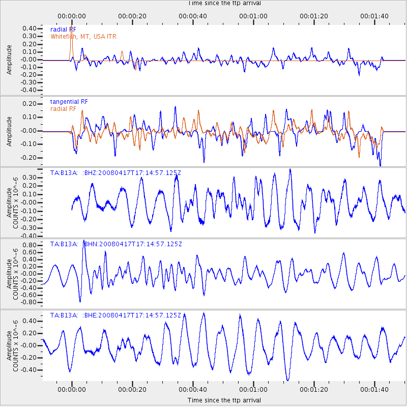
B13A Whitefish, MT, USA - Earthquake Result Viewer
*The percent match for this event was below the threshold and hence no stack was calculated.
| Earthquake location: |
Mariana Islands Region |
| Earthquake latitude/longitude: |
15.9/144.9 |
| Earthquake time(UTC): |
2008/04/17 (108) 17:02:52 GMT |
| Earthquake Depth: |
10 km |
| Earthquake Magnitude: |
5.5 MB, 5.2 MS, 5.5 MW, 5.5 MW |
| Earthquake Catalog/Contributor: |
WHDF/NEIC |
|
| Network: |
TA USArray Transportable Network (new EarthScope stations) |
| Station: |
B13A Whitefish, MT, USA |
| Lat/Lon: |
48.37 N/114.47 W |
| Elevation: |
933 m |
|
| Distance: |
85.2 deg |
| Az: |
41.116 deg |
| Baz: |
288.365 deg |
| Ray Param: |
$rayparam |
*The percent match for this event was below the threshold and hence was not used in the summary stack. |
|
| Radial Match: |
56.195587 % |
| Radial Bump: |
400 |
| Transverse Match: |
58.91907 % |
| Transverse Bump: |
353 |
| SOD ConfigId: |
2504 |
| Insert Time: |
2010-03-06 06:53:27.821 +0000 |
| GWidth: |
2.5 |
| Max Bumps: |
400 |
| Tol: |
0.001 |
|
Signal To Noise
| Channel | StoN | STA | LTA |
| TA:B13A: :BHN:20080417T17:14:57.125Z | 2.1422086 | 4.486341E-7 | 2.0942598E-7 |
| TA:B13A: :BHE:20080417T17:14:57.125Z | 1.9560711 | 2.3851052E-7 | 1.2193345E-7 |
| TA:B13A: :BHZ:20080417T17:14:57.125Z | 1.4889826 | 1.929456E-7 | 1.2958218E-7 |
| Arrivals |
| Ps | |
| PpPs | |
| PsPs/PpSs | |


