You are here: Home > Network List > TA - USArray Transportable Network (new EarthScope stations) Stations List
> Station B13A Whitefish, MT, USA > Earthquake Result Viewer
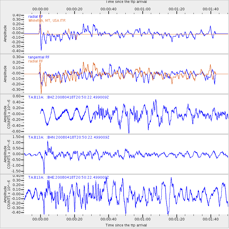
B13A Whitefish, MT, USA - Earthquake Result Viewer
*The percent match for this event was below the threshold and hence no stack was calculated.
| Earthquake location: |
Fiji Islands Region |
| Earthquake latitude/longitude: |
-17.3/-179.0 |
| Earthquake time(UTC): |
2008/04/18 (109) 20:39:07 GMT |
| Earthquake Depth: |
554 km |
| Earthquake Magnitude: |
5.9 MB, 6.3 MW, 6.3 MW |
| Earthquake Catalog/Contributor: |
WHDF/NEIC |
|
| Network: |
TA USArray Transportable Network (new EarthScope stations) |
| Station: |
B13A Whitefish, MT, USA |
| Lat/Lon: |
48.37 N/114.47 W |
| Elevation: |
933 m |
|
| Distance: |
87.0 deg |
| Az: |
37.079 deg |
| Baz: |
239.73 deg |
| Ray Param: |
$rayparam |
*The percent match for this event was below the threshold and hence was not used in the summary stack. |
|
| Radial Match: |
47.343376 % |
| Radial Bump: |
400 |
| Transverse Match: |
54.09486 % |
| Transverse Bump: |
400 |
| SOD ConfigId: |
2504 |
| Insert Time: |
2010-03-06 06:53:29.300 +0000 |
| GWidth: |
2.5 |
| Max Bumps: |
400 |
| Tol: |
0.001 |
|
Signal To Noise
| Channel | StoN | STA | LTA |
| TA:B13A: :BHN:20080418T20:50:22.499009Z | 3.722594 | 5.524305E-7 | 1.4839934E-7 |
| TA:B13A: :BHE:20080418T20:50:22.499009Z | 1.0977485 | 1.4202229E-7 | 1.2937598E-7 |
| TA:B13A: :BHZ:20080418T20:50:22.499009Z | 0.96371245 | 1.4666021E-7 | 1.5218254E-7 |
| Arrivals |
| Ps | |
| PpPs | |
| PsPs/PpSs | |


