You are here: Home > Network List > TA - USArray Transportable Network (new EarthScope stations) Stations List
> Station B13A Whitefish, MT, USA > Earthquake Result Viewer
B13A Whitefish, MT, USA - Earthquake Result Viewer
*The percent match for this event was below the threshold and hence no stack was calculated.
| Earthquake location: |
Near East Coast Of Honshu, Japan |
| Earthquake latitude/longitude: |
36.1/141.7 |
| Earthquake time(UTC): |
2008/05/08 (129) 23:21:06 GMT |
| Earthquake Depth: |
17 km |
| Earthquake Magnitude: |
5.6 MB, 5.2 MS, 5.6 MW, 5.5 MW |
| Earthquake Catalog/Contributor: |
WHDF/NEIC |
|
| Network: |
TA USArray Transportable Network (new EarthScope stations) |
| Station: |
B13A Whitefish, MT, USA |
| Lat/Lon: |
48.37 N/114.47 W |
| Elevation: |
933 m |
|
| Distance: |
72.1 deg |
| Az: |
42.88 deg |
| Baz: |
304.267 deg |
| Ray Param: |
$rayparam |
*The percent match for this event was below the threshold and hence was not used in the summary stack. |
|
| Radial Match: |
59.383144 % |
| Radial Bump: |
400 |
| Transverse Match: |
45.186466 % |
| Transverse Bump: |
400 |
| SOD ConfigId: |
2504 |
| Insert Time: |
2010-03-06 06:53:30.193 +0000 |
| GWidth: |
2.5 |
| Max Bumps: |
400 |
| Tol: |
0.001 |
|
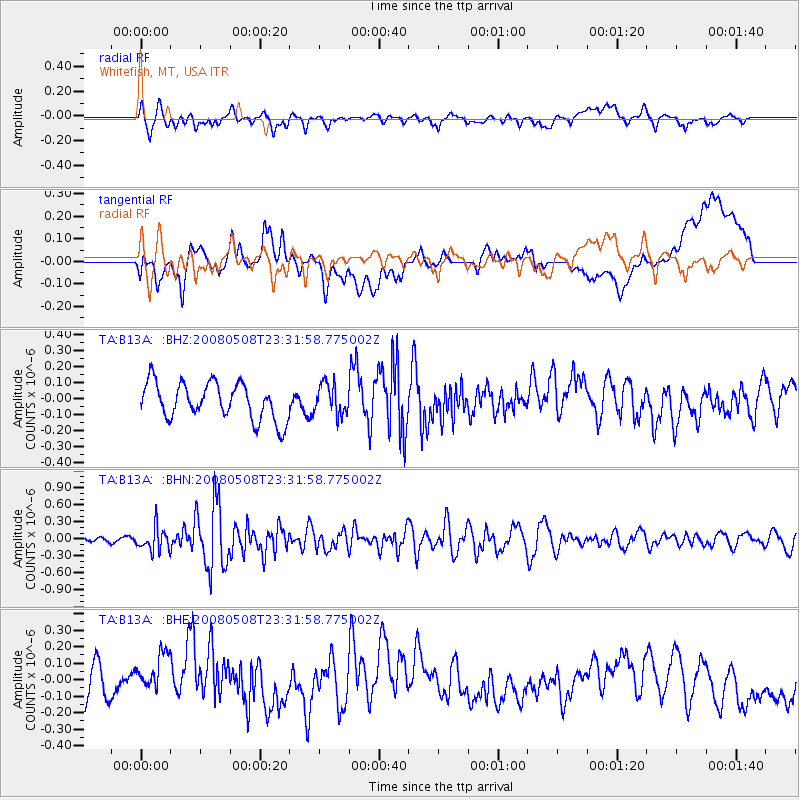
Signal To Noise
| Channel | StoN | STA | LTA |
| TA:B13A: :BHN:20080508T23:31:58.775002Z | 2.9741943 | 2.044844E-7 | 6.875287E-8 |
| TA:B13A: :BHE:20080508T23:31:58.775002Z | 1.6495967 | 1.5219503E-7 | 9.2261956E-8 |
| TA:B13A: :BHZ:20080508T23:31:58.775002Z | 0.82113445 | 9.444702E-8 | 1.1502016E-7 |
| Arrivals |
| Ps | |
| PpPs | |
| PsPs/PpSs | |


