You are here: Home > Network List > TA - USArray Transportable Network (new EarthScope stations) Stations List
> Station B13A Whitefish, MT, USA > Earthquake Result Viewer
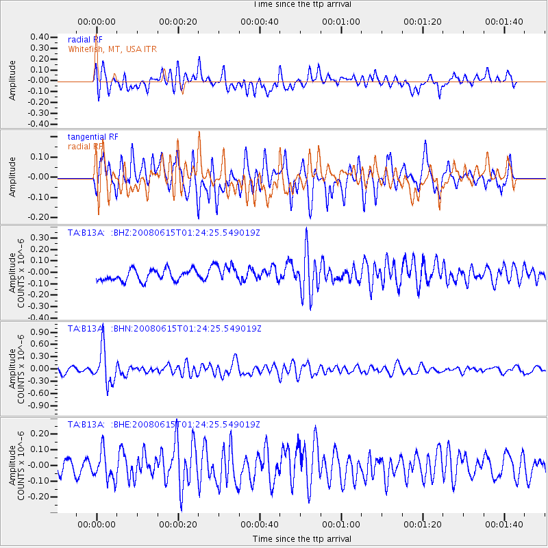
B13A Whitefish, MT, USA - Earthquake Result Viewer
*The percent match for this event was below the threshold and hence no stack was calculated.
| Earthquake location: |
Fiji Islands Region |
| Earthquake latitude/longitude: |
-17.7/-179.7 |
| Earthquake time(UTC): |
2008/06/15 (167) 01:13:11 GMT |
| Earthquake Depth: |
611 km |
| Earthquake Magnitude: |
5.5 MB, 5.9 MW, 5.9 MW |
| Earthquake Catalog/Contributor: |
WHDF/NEIC |
|
| Network: |
TA USArray Transportable Network (new EarthScope stations) |
| Station: |
B13A Whitefish, MT, USA |
| Lat/Lon: |
48.37 N/114.47 W |
| Elevation: |
933 m |
|
| Distance: |
87.7 deg |
| Az: |
37.306 deg |
| Baz: |
240.035 deg |
| Ray Param: |
$rayparam |
*The percent match for this event was below the threshold and hence was not used in the summary stack. |
|
| Radial Match: |
56.55092 % |
| Radial Bump: |
400 |
| Transverse Match: |
64.28498 % |
| Transverse Bump: |
400 |
| SOD ConfigId: |
2504 |
| Insert Time: |
2010-03-06 06:53:39.610 +0000 |
| GWidth: |
2.5 |
| Max Bumps: |
400 |
| Tol: |
0.001 |
|
Signal To Noise
| Channel | StoN | STA | LTA |
| TA:B13A: :BHN:20080615T01:24:25.549019Z | 7.6877236 | 4.365974E-7 | 5.6791503E-8 |
| TA:B13A: :BHE:20080615T01:24:25.549019Z | 2.064623 | 9.0265765E-8 | 4.3720213E-8 |
| TA:B13A: :BHZ:20080615T01:24:25.549019Z | 1.5192345 | 7.4556375E-8 | 4.907496E-8 |
| Arrivals |
| Ps | |
| PpPs | |
| PsPs/PpSs | |


