You are here: Home > Network List > TA - USArray Transportable Network (new EarthScope stations) Stations List
> Station B13A Whitefish, MT, USA > Earthquake Result Viewer
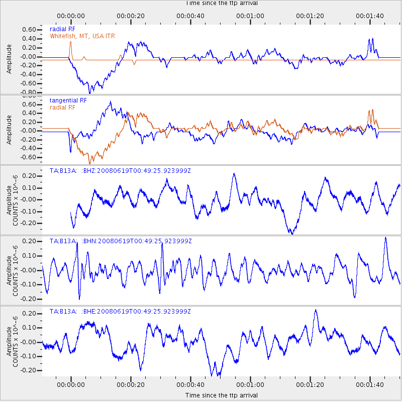
B13A Whitefish, MT, USA - Earthquake Result Viewer
*The percent match for this event was below the threshold and hence no stack was calculated.
| Earthquake location: |
New Britain Region, P.N.G. |
| Earthquake latitude/longitude: |
-4.9/151.8 |
| Earthquake time(UTC): |
2008/06/19 (171) 00:36:45 GMT |
| Earthquake Depth: |
143 km |
| Earthquake Magnitude: |
5.5 MW, 5.2 MB, 5.4 MW |
| Earthquake Catalog/Contributor: |
WHDF/NEIC |
|
| Network: |
TA USArray Transportable Network (new EarthScope stations) |
| Station: |
B13A Whitefish, MT, USA |
| Lat/Lon: |
48.37 N/114.47 W |
| Elevation: |
933 m |
|
| Distance: |
96.2 deg |
| Az: |
42.004 deg |
| Baz: |
269.538 deg |
| Ray Param: |
$rayparam |
*The percent match for this event was below the threshold and hence was not used in the summary stack. |
|
| Radial Match: |
55.266827 % |
| Radial Bump: |
400 |
| Transverse Match: |
47.56231 % |
| Transverse Bump: |
400 |
| SOD ConfigId: |
2504 |
| Insert Time: |
2010-03-06 06:53:41.586 +0000 |
| GWidth: |
2.5 |
| Max Bumps: |
400 |
| Tol: |
0.001 |
|
Signal To Noise
| Channel | StoN | STA | LTA |
| TA:B13A: :BHN:20080619T00:49:25.923999Z | 1.3174535 | 8.880432E-8 | 6.7406035E-8 |
| TA:B13A: :BHE:20080619T00:49:25.923999Z | 2.4686139 | 7.9735294E-8 | 3.229962E-8 |
| TA:B13A: :BHZ:20080619T00:49:25.923999Z | 1.4775888 | 1.16058686E-7 | 7.8545995E-8 |
| Arrivals |
| Ps | |
| PpPs | |
| PsPs/PpSs | |


