You are here: Home > Network List > US - United States National Seismic Network Stations List
> Station EGMT Eagleton, Montana, USA > Earthquake Result Viewer
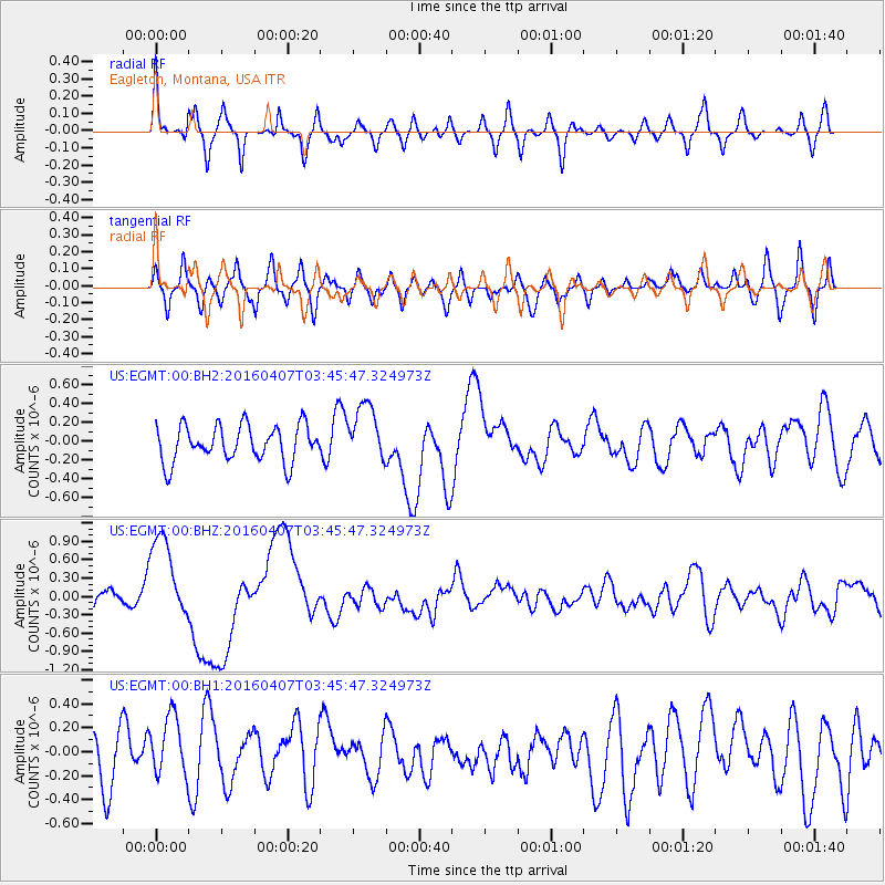
EGMT Eagleton, Montana, USA - Earthquake Result Viewer
*The percent match for this event was below the threshold and hence no stack was calculated.
| Earthquake location: |
Vanuatu Islands |
| Earthquake latitude/longitude: |
-14.0/166.6 |
| Earthquake time(UTC): |
2016/04/07 (098) 03:32:53 GMT |
| Earthquake Depth: |
27 km |
| Earthquake Magnitude: |
6.7 MWW, 6.5 MWB, 6.9 MI |
| Earthquake Catalog/Contributor: |
NEIC PDE/NEIC COMCAT |
|
| Network: |
US United States National Seismic Network |
| Station: |
EGMT Eagleton, Montana, USA |
| Lat/Lon: |
48.02 N/109.75 W |
| Elevation: |
1055 m |
|
| Distance: |
96.1 deg |
| Az: |
42.145 deg |
| Baz: |
255.998 deg |
| Ray Param: |
$rayparam |
*The percent match for this event was below the threshold and hence was not used in the summary stack. |
|
| Radial Match: |
63.57971 % |
| Radial Bump: |
400 |
| Transverse Match: |
48.89679 % |
| Transverse Bump: |
400 |
| SOD ConfigId: |
1475611 |
| Insert Time: |
2016-04-21 03:39:50.580 +0000 |
| GWidth: |
2.5 |
| Max Bumps: |
400 |
| Tol: |
0.001 |
|
Signal To Noise
| Channel | StoN | STA | LTA |
| US:EGMT:00:BHZ:20160407T03:45:47.324973Z | 7.8952894 | 7.099565E-7 | 8.9921535E-8 |
| US:EGMT:00:BH1:20160407T03:45:47.324973Z | 1.0913954 | 2.697994E-7 | 2.472059E-7 |
| US:EGMT:00:BH2:20160407T03:45:47.324973Z | 1.6070844 | 3.0543376E-7 | 1.9005459E-7 |
| Arrivals |
| Ps | |
| PpPs | |
| PsPs/PpSs | |


