You are here: Home > Network List > TA - USArray Transportable Network (new EarthScope stations) Stations List
> Station F26K Sheenjek River, AK, USA > Earthquake Result Viewer
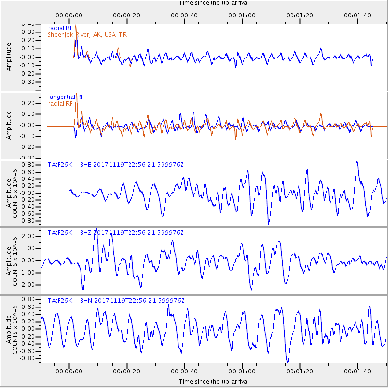
F26K Sheenjek River, AK, USA - Earthquake Result Viewer
*The percent match for this event was below the threshold and hence no stack was calculated.
| Earthquake location: |
Loyalty Islands |
| Earthquake latitude/longitude: |
-21.3/168.5 |
| Earthquake time(UTC): |
2017/11/19 (323) 22:43:29 GMT |
| Earthquake Depth: |
25 km |
| Earthquake Magnitude: |
7.3 Mi |
| Earthquake Catalog/Contributor: |
NEIC PDE/at |
|
| Network: |
TA USArray Transportable Network (new EarthScope stations) |
| Station: |
F26K Sheenjek River, AK, USA |
| Lat/Lon: |
67.69 N/144.15 W |
| Elevation: |
683 m |
|
| Distance: |
95.3 deg |
| Az: |
16.379 deg |
| Baz: |
223.542 deg |
| Ray Param: |
$rayparam |
*The percent match for this event was below the threshold and hence was not used in the summary stack. |
|
| Radial Match: |
71.30194 % |
| Radial Bump: |
400 |
| Transverse Match: |
45.098614 % |
| Transverse Bump: |
400 |
| SOD ConfigId: |
13570011 |
| Insert Time: |
2019-04-29 07:09:27.021 +0000 |
| GWidth: |
2.5 |
| Max Bumps: |
400 |
| Tol: |
0.001 |
|
Signal To Noise
| Channel | StoN | STA | LTA |
| TA:F26K: :BHZ:20171119T22:56:21.599976Z | 3.3990183 | 7.4231525E-7 | 2.1839108E-7 |
| TA:F26K: :BHN:20171119T22:56:21.599976Z | 1.1317623 | 2.7614178E-7 | 2.4399273E-7 |
| TA:F26K: :BHE:20171119T22:56:21.599976Z | 3.0053306 | 3.1834736E-7 | 1.0592757E-7 |
| Arrivals |
| Ps | |
| PpPs | |
| PsPs/PpSs | |


