You are here: Home > Network List > TA - USArray Transportable Network (new EarthScope stations) Stations List
> Station G16K Koyuk River, AK, USA > Earthquake Result Viewer
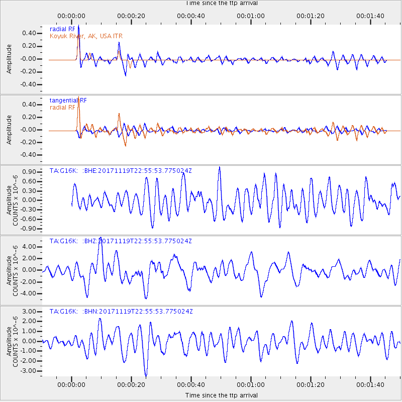
G16K Koyuk River, AK, USA - Earthquake Result Viewer
*The percent match for this event was below the threshold and hence no stack was calculated.
| Earthquake location: |
Loyalty Islands |
| Earthquake latitude/longitude: |
-21.3/168.5 |
| Earthquake time(UTC): |
2017/11/19 (323) 22:43:29 GMT |
| Earthquake Depth: |
25 km |
| Earthquake Magnitude: |
7.3 Mi |
| Earthquake Catalog/Contributor: |
NEIC PDE/at |
|
| Network: |
TA USArray Transportable Network (new EarthScope stations) |
| Station: |
G16K Koyuk River, AK, USA |
| Lat/Lon: |
65.39 N/162.35 W |
| Elevation: |
169 m |
|
| Distance: |
89.3 deg |
| Az: |
11.767 deg |
| Baz: |
207.013 deg |
| Ray Param: |
$rayparam |
*The percent match for this event was below the threshold and hence was not used in the summary stack. |
|
| Radial Match: |
73.26733 % |
| Radial Bump: |
400 |
| Transverse Match: |
62.386368 % |
| Transverse Bump: |
400 |
| SOD ConfigId: |
13570011 |
| Insert Time: |
2019-04-29 07:09:30.070 +0000 |
| GWidth: |
2.5 |
| Max Bumps: |
400 |
| Tol: |
0.001 |
|
Signal To Noise
| Channel | StoN | STA | LTA |
| TA:G16K: :BHZ:20171119T22:55:53.775024Z | 2.8929543 | 1.3715512E-6 | 4.7410055E-7 |
| TA:G16K: :BHN:20171119T22:55:53.775024Z | 1.2070862 | 4.861808E-7 | 4.0277223E-7 |
| TA:G16K: :BHE:20171119T22:55:53.775024Z | 2.2777572 | 4.6867137E-7 | 2.0576002E-7 |
| Arrivals |
| Ps | |
| PpPs | |
| PsPs/PpSs | |


