You are here: Home > Network List > TA - USArray Transportable Network (new EarthScope stations) Stations List
> Station G31M Satah River, YT, CAN > Earthquake Result Viewer
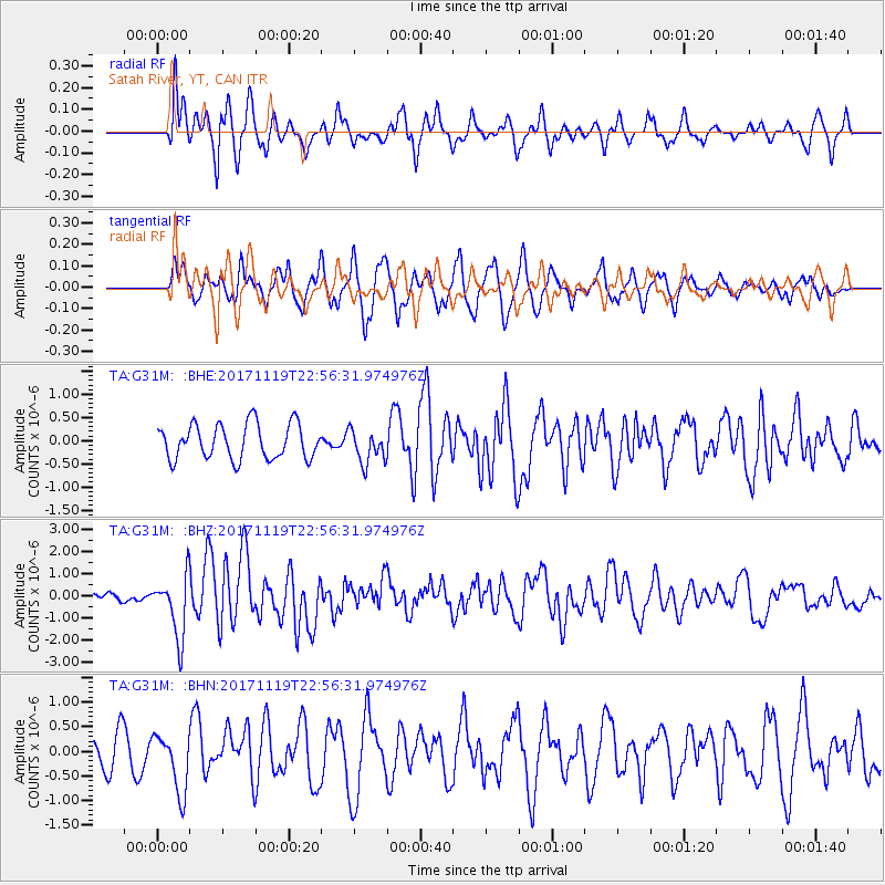
G31M Satah River, YT, CAN - Earthquake Result Viewer
*The percent match for this event was below the threshold and hence no stack was calculated.
| Earthquake location: |
Loyalty Islands |
| Earthquake latitude/longitude: |
-21.3/168.5 |
| Earthquake time(UTC): |
2017/11/19 (323) 22:43:29 GMT |
| Earthquake Depth: |
25 km |
| Earthquake Magnitude: |
7.3 Mi |
| Earthquake Catalog/Contributor: |
NEIC PDE/at |
|
| Network: |
TA USArray Transportable Network (new EarthScope stations) |
| Station: |
G31M Satah River, YT, CAN |
| Lat/Lon: |
66.92 N/134.27 W |
| Elevation: |
61 m |
|
| Distance: |
97.6 deg |
| Az: |
19.538 deg |
| Baz: |
232.29 deg |
| Ray Param: |
$rayparam |
*The percent match for this event was below the threshold and hence was not used in the summary stack. |
|
| Radial Match: |
68.59198 % |
| Radial Bump: |
400 |
| Transverse Match: |
58.145622 % |
| Transverse Bump: |
400 |
| SOD ConfigId: |
13570011 |
| Insert Time: |
2019-04-29 07:09:39.254 +0000 |
| GWidth: |
2.5 |
| Max Bumps: |
400 |
| Tol: |
0.001 |
|
Signal To Noise
| Channel | StoN | STA | LTA |
| TA:G31M: :BHZ:20171119T22:56:31.974976Z | 5.391445 | 1.3949052E-6 | 2.5872566E-7 |
| TA:G31M: :BHN:20171119T22:56:31.974976Z | 1.8158925 | 5.996583E-7 | 3.3022786E-7 |
| TA:G31M: :BHE:20171119T22:56:31.974976Z | 0.8955323 | 3.399425E-7 | 3.7959825E-7 |
| Arrivals |
| Ps | |
| PpPs | |
| PsPs/PpSs | |


