You are here: Home > Network List > TA - USArray Transportable Network (new EarthScope stations) Stations List
> Station I23K Minto, Yukon-Koyukuk, AK, USA > Earthquake Result Viewer
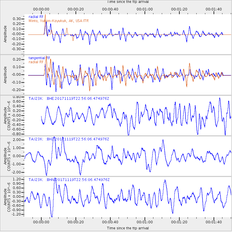
I23K Minto, Yukon-Koyukuk, AK, USA - Earthquake Result Viewer
*The percent match for this event was below the threshold and hence no stack was calculated.
| Earthquake location: |
Loyalty Islands |
| Earthquake latitude/longitude: |
-21.3/168.5 |
| Earthquake time(UTC): |
2017/11/19 (323) 22:43:29 GMT |
| Earthquake Depth: |
25 km |
| Earthquake Magnitude: |
7.3 Mi |
| Earthquake Catalog/Contributor: |
NEIC PDE/at |
|
| Network: |
TA USArray Transportable Network (new EarthScope stations) |
| Station: |
I23K Minto, Yukon-Koyukuk, AK, USA |
| Lat/Lon: |
65.15 N/149.36 W |
| Elevation: |
149 m |
|
| Distance: |
92.0 deg |
| Az: |
16.482 deg |
| Baz: |
218.759 deg |
| Ray Param: |
$rayparam |
*The percent match for this event was below the threshold and hence was not used in the summary stack. |
|
| Radial Match: |
71.709526 % |
| Radial Bump: |
400 |
| Transverse Match: |
57.960476 % |
| Transverse Bump: |
400 |
| SOD ConfigId: |
13570011 |
| Insert Time: |
2019-04-29 07:09:51.952 +0000 |
| GWidth: |
2.5 |
| Max Bumps: |
400 |
| Tol: |
0.001 |
|
Signal To Noise
| Channel | StoN | STA | LTA |
| TA:I23K: :BHZ:20171119T22:56:06.474976Z | 3.7572827 | 1.0546893E-6 | 2.807053E-7 |
| TA:I23K: :BHN:20171119T22:56:06.474976Z | 1.5411184 | 3.9714487E-7 | 2.5769913E-7 |
| TA:I23K: :BHE:20171119T22:56:06.474976Z | 1.1111125 | 2.5528212E-7 | 2.2975361E-7 |
| Arrivals |
| Ps | |
| PpPs | |
| PsPs/PpSs | |


