You are here: Home > Network List > US - United States National Seismic Network Stations List
> Station MSO Missoula, Montana, USA > Earthquake Result Viewer
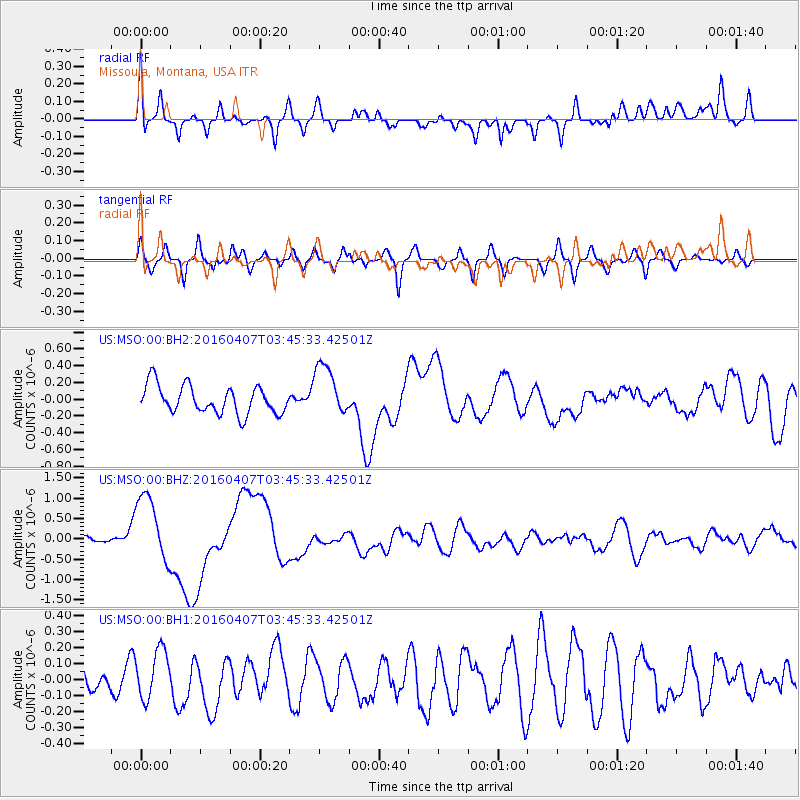
MSO Missoula, Montana, USA - Earthquake Result Viewer
*The percent match for this event was below the threshold and hence no stack was calculated.
| Earthquake location: |
Vanuatu Islands |
| Earthquake latitude/longitude: |
-14.0/166.6 |
| Earthquake time(UTC): |
2016/04/07 (098) 03:32:53 GMT |
| Earthquake Depth: |
27 km |
| Earthquake Magnitude: |
6.7 MWW, 6.5 MWB, 6.9 MI |
| Earthquake Catalog/Contributor: |
NEIC PDE/NEIC COMCAT |
|
| Network: |
US United States National Seismic Network |
| Station: |
MSO Missoula, Montana, USA |
| Lat/Lon: |
46.83 N/113.94 W |
| Elevation: |
1264 m |
|
| Distance: |
93.0 deg |
| Az: |
42.536 deg |
| Baz: |
252.893 deg |
| Ray Param: |
$rayparam |
*The percent match for this event was below the threshold and hence was not used in the summary stack. |
|
| Radial Match: |
77.5206 % |
| Radial Bump: |
400 |
| Transverse Match: |
47.18735 % |
| Transverse Bump: |
400 |
| SOD ConfigId: |
1475611 |
| Insert Time: |
2016-04-21 03:40:26.013 +0000 |
| GWidth: |
2.5 |
| Max Bumps: |
400 |
| Tol: |
0.001 |
|
Signal To Noise
| Channel | StoN | STA | LTA |
| US:MSO:00:BHZ:20160407T03:45:33.42501Z | 6.3755236 | 8.520323E-7 | 1.3364115E-7 |
| US:MSO:00:BH1:20160407T03:45:33.42501Z | 1.1943245 | 1.539279E-7 | 1.2888282E-7 |
| US:MSO:00:BH2:20160407T03:45:33.42501Z | 1.890174 | 3.1411972E-7 | 1.6618561E-7 |
| Arrivals |
| Ps | |
| PpPs | |
| PsPs/PpSs | |


